Chester Springs night lights from space
Night Light of Chester Springs (Pennsylvania) from space (United States) Src. Average luminocity for 10x10km area is 35.9951% and for 50x50km: 42.9898%.
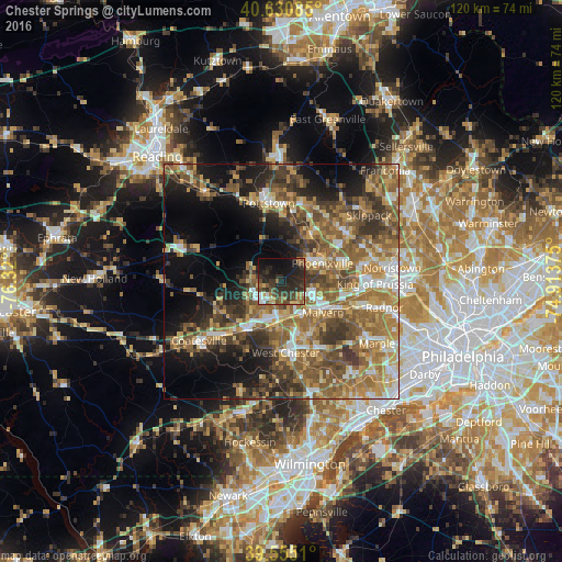
Analysis of Chester Springs night lights 2016
Square area 10x10 km:
 4.22%
4.22%90-99
2.11%80-89
4.22%70-79
2.11%60-69
6.33%50-59
6.33%40-49
9.74%30-39
10.71%20-29
21.59%10-19
23.21%0-9
9.42%Square area 50x50 km:
4.69%90-99
4.9%80-89
6.23%70-79
7.36%60-69
9.2%50-59
10.97%40-49
8.12%30-39
8.27%20-29
7.42%10-19
12.95%0-9
19.89%Clear (daylight) street map image can be seen on geolist.org.
Map coordinates:
40° 37' 51.1" North, 76° 19' 12" West
40° 5' 42.4" North, 75° 37' 0.7" West
39° 33' 18.4" North, 74° 54' 49.5" West
Some cities around Chester Springs sort by population:
• Pottstown
16.9 km =10.5 mi,  350°
350°
• West Chester
14.9 km =9.3 mi,  177°
177°
• Phoenixville
9.5 km =5.9 mi,  65°
65°
• Audubon
16.2 km =10.1 mi,  76°
76°
• Sanatoga
16.8 km =10.4 mi,  6°
6°
• Downingtown
12.3 km =7.6 mi,  216°
216°
• Lionville
5.9 km =3.7 mi, 218°
• Paoli
13.3 km =8.3 mi,  116°
116°
5184082 (p: 7,520)
Sources (retrieved 2019-11-25):
» Earth at Night: Flat Maps 2012, 2016