Park City night lights from space
Night Light of Park City (Illinois) from space (United States) Src. Average luminocity for 10x10km area is 86.9921% and for 50x50km: 38.7528%.
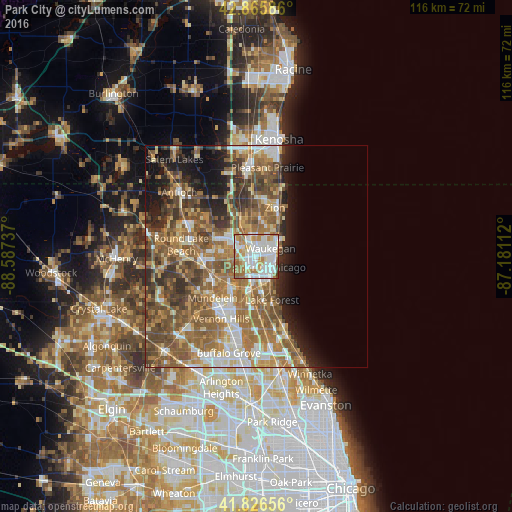
Analysis of Park City night lights 2016
Square area 10x10 km:
 29.52%
90-99
31.27%80-89
6.83%70-79
11.59%60-69
14.76%50-59
2.86%40-49
2.7%30-39
0.48%20-29
0%10-19
0%0-9
0%Square area 50x50 km:
5.37%90-99
6.01%80-89
4.42%70-79
5.77%60-69
9.59%50-59
10.17%40-49
7.58%30-39
4.89%20-29
5.54%10-19
7.46%0-9
33.2%Clear (daylight) street map image can be seen on geolist.org.
Map coordinates:
42° 51' 57.1" North, 88° 35' 14.5" West
42° 20' 54.1" North, 87° 53' 3.3" West
41° 49' 35.6" North, 87° 10' 52" West
Some cities around Park City sort by population:
• Waukegan
3.7 km =2.3 mi,  62°
62°
• Gurnee
2.8 km =1.7 mi,  329°
329°
• North Chicago
4.4 km =2.7 mi,  125°
125°
• Libertyville
9.2 km =5.7 mi,  217°
217°
• Beach Park
8.5 km =5.3 mi,  15°
15°
• Gages Lake
8.1 km =5 mi,  272°
272°
• Lake Bluff
8.7 km =5.4 mi,  151°
151°
• Grandwood Park
9.8 km =6.1 mi,  300°
300°
4905334 (p: 7,392)
Sources (retrieved 2019-11-25):
» Earth at Night: Flat Maps 2012, 2016