Gages Lake night lights from space
Night Light of Gages Lake (Illinois) from space (United States) Src. Average luminocity for 10x10km area is 68.7603% and for 50x50km: 45.2491%.
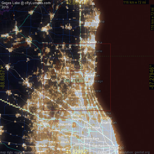
Analysis of Gages Lake night lights 2016
Square area 10x10 km:
 8.41%
8.41%90-99
12.7%80-89
5.87%70-79
9.84%60-69
27.62%50-59
21.9%40-49
8.89%30-39
4.76%20-29
0%10-19
0%0-9
0%Square area 50x50 km:
5.61%90-99
6.43%80-89
5.08%70-79
6.69%60-69
10.98%50-59
11.55%40-49
10.48%30-39
6.7%20-29
8.05%10-19
9.86%0-9
18.58%Clear (daylight) street map image can be seen on geolist.org.
Map coordinates:
42° 52' 9" North, 88° 41' 8.6" West
42° 21' 6.1" North, 87° 58' 57.3" West
41° 49' 47.7" North, 87° 16' 46.1" West
Some cities around Gages Lake sort by population:
• Gurnee
6.9 km =4.3 mi,  72°
72°
• Grayslake
4.9 km =3 mi,  260°
260°
• Libertyville
8 km =5 mi,  162°
162°
• Round Lake
9.1 km =5.7 mi,  271°
271°
• Lindenhurst
7.5 km =4.7 mi,  331°
331°
• Round Lake Park
7.8 km =4.8 mi, 274°
• Park City
8.1 km =5 mi,  92°
92°
• Grandwood Park
4.6 km =2.9 mi,  355°
355°
4893371 (p: 10,198)
Sources (retrieved 2019-11-25):
» Earth at Night: Flat Maps 2012, 2016