Grandwood Park night lights from space
Night Light of Grandwood Park (Illinois) from space (United States) Src. Average luminocity for 10x10km area is 63.5254% and for 50x50km: 42.3075%.
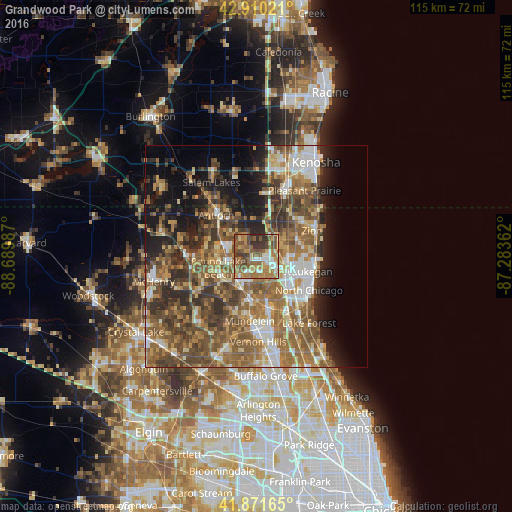
Analysis of Grandwood Park night lights 2016
Square area 10x10 km:
 6.51%
6.51%90-99
9.37%80-89
6.83%70-79
9.84%60-69
20.48%50-59
20.63%40-49
13.65%30-39
8.73%20-29
3.97%10-19
0%0-9
0%Square area 50x50 km:
5.11%90-99
5.79%80-89
4.74%70-79
6.03%60-69
10.18%50-59
10.75%40-49
9.97%30-39
6.56%20-29
8.01%10-19
10.34%0-9
22.52%Clear (daylight) street map image can be seen on geolist.org.
Map coordinates:
42° 54' 36.8" North, 88° 41' 23.5" West
42° 23' 35.1" North, 87° 59' 12.3" West
41° 52' 17.9" North, 87° 17' 1" West
Some cities around Grandwood Park sort by population:
• Gurnee
7.4 km =4.6 mi,  110°
110°
• Round Lake Beach
8.8 km =5.5 mi,  254°
254°
• Grayslake
7 km =4.3 mi,  219°
219°
• Lindenhurst
3.8 km =2.4 mi,  300°
300°
• Gages Lake
4.6 km =2.9 mi,  175°
175°
• Lake Villa
7.6 km =4.7 mi,  290°
290°
• Round Lake Park
8.4 km =5.2 mi,  241°
241°
• Park City
9.8 km =6.1 mi,  120°
120°
4894360 (p: 5,202)
Sources (retrieved 2019-11-25):
» Earth at Night: Flat Maps 2012, 2016