Beach Park night lights from space
Night Light of Beach Park (Illinois) from space (United States) Src. Average luminocity for 10x10km area is 63.9651% and for 50x50km: 32.3395%.
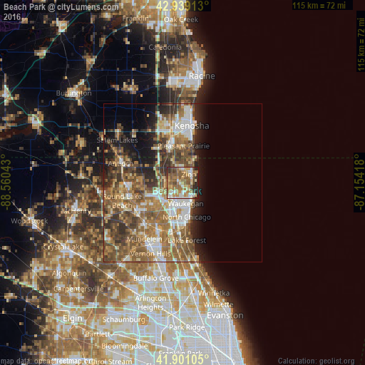
Analysis of Beach Park night lights 2016
Square area 10x10 km:
 8.41%
8.41%90-99
8.57%80-89
8.41%70-79
14.76%60-69
16.51%50-59
18.41%40-49
9.68%30-39
4.6%20-29
8.1%10-19
2.54%0-9
0%Square area 50x50 km:
4.42%90-99
4.99%80-89
3.69%70-79
4.56%60-69
7.4%50-59
8.28%40-49
6.32%30-39
4.71%20-29
5.66%10-19
7.3%0-9
42.66%Clear (daylight) street map image can be seen on geolist.org.
Map coordinates:
42° 56' 20.9" North, 88° 33' 37.5" West
42° 25' 20.1" North, 87° 51' 26.3" West
41° 54' 3.8" North, 87° 9' 15" West
Some cities around Beach Park sort by population:
• Waukegan
6.6 km =4.1 mi,  171°
171°
• Gurnee
6.8 km =4.2 mi,  212°
212°
• North Chicago
10.8 km =6.7 mi, 172°
• Zion
3.3 km =2.1 mi,  37°
37°
• Gages Lake
12.9 km =8 mi,  232°
232°
• Park City
8.5 km =5.3 mi,  195°
195°
• Winthrop Harbor
6.9 km =4.3 mi,  23°
23°
• Grandwood Park
11.1 km =6.9 mi,  253°
253°
4884249 (p: 13,976)
Sources (retrieved 2019-11-25):
» Earth at Night: Flat Maps 2012, 2016