Oxon Hill-Glassmanor night lights from space
Night Light of Oxon Hill-Glassmanor (Maryland) from space (United States) Src. Average luminocity for 10x10km area is 87.2517% and for 50x50km: 65.2964%.
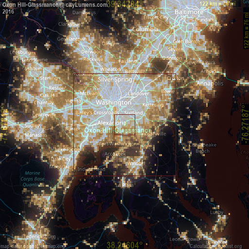

Analysis of Oxon Hill-Glassmanor night lights 2016
Square area 10x10 km:
 23.47%
90-99
31.29%80-89
15.48%70-79
15.82%60-69
10.37%50-59
2.55%40-49
1.02%30-39
0%20-29
0%10-19
0%0-9
0%Square area 50x50 km:
20.91%90-99
14.2%80-89
9.85%70-79
11.37%60-69
7.78%50-59
5.93%40-49
3.7%30-39
4.55%20-29
4.92%10-19
6.33%0-9
10.44%Clear (daylight) street map image can be seen on geolist.org.
Map coordinates:
39° 20' 31.3" North, 77° 40' 41.2" West
38° 47' 46.1" North, 76° 58' 30" West
38° 14' 45.7" North, 76° 16' 18.7" West
Some cities around Oxon Hill-Glassmanor sort by population:
• Alexandria
6.3 km =3.9 mi,  278°
278°
• Camp Springs
6 km =3.7 mi,  81°
81°
• Glassmanor
3.3 km =2.1 mi,  321°
321°
• Hillcrest Heights
4.3 km =2.7 mi,  18°
18°
• Friendly
4.9 km =3 mi,  183°
183°
• Temple Hills
3.2 km =2 mi,  52°
52°
• Silver Hill
5.7 km =3.5 mi,  26°
26°
• Marlow Heights
4.6 km =2.9 mi, 26°
7258432 (p: 35,355)
Sources (retrieved 2019-11-25):
» Earth at Night: Flat Maps 2012, 2016