Camp Springs night lights from space
Night Light of Camp Springs (Maryland) from space (United States) Src. Average luminocity for 10x10km area is 88.4949% and for 50x50km: 60.1761%.
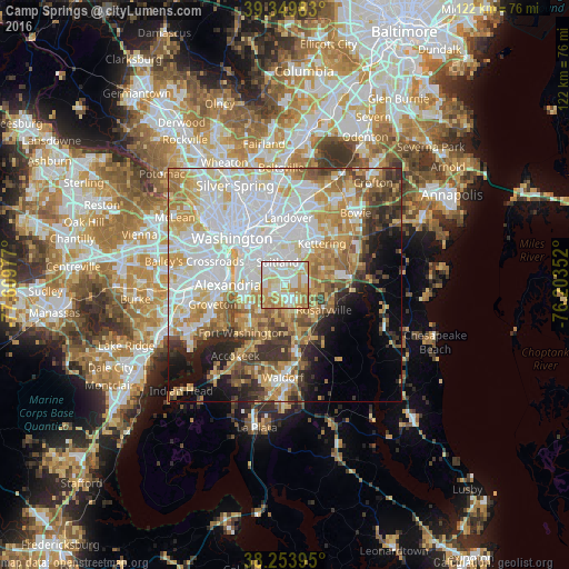
Analysis of Camp Springs night lights 2016
Square area 10x10 km:
 23.81%
90-99
30.44%80-89
19.73%70-79
15.82%60-69
10.2%50-59
0%40-49
0%30-39
0%20-29
0%10-19
0%0-9
0%Square area 50x50 km:
19.29%90-99
12.95%80-89
8.95%70-79
9.2%60-69
7.13%50-59
5.75%40-49
4%30-39
5.15%20-29
5.07%10-19
6.54%0-9
15.97%Clear (daylight) street map image can be seen on geolist.org.
Map coordinates:
39° 20' 59.4" North, 77° 36' 35.2" West
38° 48' 14.4" North, 76° 54' 23.9" West
38° 15' 14.2" North, 76° 12' 12.7" West
Some cities around Camp Springs sort by population:
• Clinton
4.4 km =2.7 mi,  170°
170°
• Suitland-Silver Hill
5 km =3.1 mi,  340°
340°
• Suitland
5.2 km =3.2 mi, 343°
• Hillcrest Heights
5.6 km =3.5 mi,  305°
305°
• Forestville
5.3 km =3.3 mi,  30°
30°
• Temple Hills
3.5 km =2.2 mi,  288°
288°
• Silver Hill
5.4 km =3.4 mi,  321°
321°
• Marlow Heights
5.1 km =3.2 mi, 310°
4350288 (p: 19,096)
Sources (retrieved 2019-11-25):
» Earth at Night: Flat Maps 2012, 2016