Marlow Heights night lights from space
Night Light of Marlow Heights (Maryland) from space (United States) Src. Average luminocity for 10x10km area is 96.7823% and for 50x50km: 67.3771%.
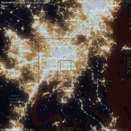
Analysis of Marlow Heights night lights 2016
Square area 10x10 km:
 45.92%
90-99
41.5%80-89
10.71%70-79
1.87%60-69
0%50-59
0%40-49
0%30-39
0%20-29
0%10-19
0%0-9
0%Square area 50x50 km:
21.59%90-99
15.26%80-89
10.42%70-79
10.96%60-69
7.87%50-59
6.46%40-49
3.86%30-39
4.8%20-29
4.42%10-19
5.4%0-9
8.95%Clear (daylight) street map image can be seen on geolist.org.
Map coordinates:
39° 22' 44.6" North, 77° 39' 17.2" West
38° 50' 0.4" North, 76° 57' 5.9" West
38° 17' 1.1" North, 76° 14' 54.7" West
Some cities around Marlow Heights sort by population:
• Oxon Hill-Glassmanor
4.6 km =2.9 mi,  206°
206°
• Suitland-Silver Hill
2.7 km =1.7 mi,  56°
56°
• Suitland
2.9 km =1.8 mi,  54°
54°
• Oxon Hill
4.7 km =2.9 mi,  224°
224°
• Glassmanor
4.4 km =2.7 mi,  248°
248°
• Hillcrest Heights
0.7 km =0.4 mi,  264°
264°
• Temple Hills
2.2 km =1.4 mi,  166°
166°
• Silver Hill
1.1 km =0.7 mi,  28°
28°
4361721 (p: 5,618)
Sources (retrieved 2019-11-25):
» Earth at Night: Flat Maps 2012, 2016