Hillcrest Heights night lights from space
Night Light of Hillcrest Heights (Maryland) from space (United States) Src. Average luminocity for 10x10km area is 97.017% and for 50x50km: 67.9931%.
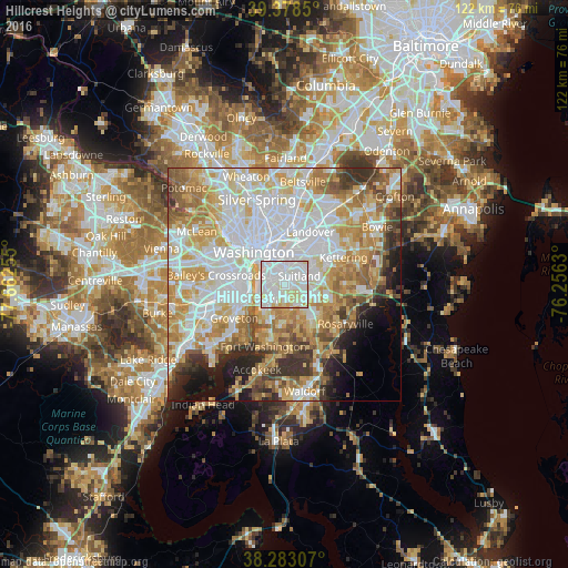
Analysis of Hillcrest Heights night lights 2016
Square area 10x10 km:
 46.43%
90-99
42.18%80-89
10.03%70-79
1.36%60-69
0%50-59
0%40-49
0%30-39
0%20-29
0%10-19
0%0-9
0%Square area 50x50 km:
21.81%90-99
15.41%80-89
10.45%70-79
11.17%60-69
7.97%50-59
6.52%40-49
3.96%30-39
4.8%20-29
4.29%10-19
5.23%0-9
8.38%Clear (daylight) street map image can be seen on geolist.org.
Map coordinates:
39° 22' 42.6" North, 77° 39' 45.2" West
38° 49' 58.4" North, 76° 57' 33.9" West
38° 16' 59.1" North, 76° 15' 22.7" West
Some cities around Hillcrest Heights sort by population:
• Oxon Hill-Glassmanor
4.3 km =2.7 mi,  198°
198°
• Suitland-Silver Hill
3.3 km =2.1 mi,  61°
61°
• Suitland
3.5 km =2.2 mi, 60°
• Oxon Hill
4.2 km =2.6 mi,  218°
218°
• Glassmanor
3.7 km =2.3 mi,  245°
245°
• Temple Hills
2.4 km =1.5 mi,  150°
150°
• Silver Hill
1.5 km =0.9 mi,  50°
50°
• Marlow Heights
0.7 km =0.4 mi,  84°
84°
4358082 (p: 16,469)
Sources (retrieved 2019-11-25):
» Earth at Night: Flat Maps 2012, 2016