Friendly night lights from space
Night Light of Friendly (Maryland) from space (United States) Src. Average luminocity for 10x10km area is 71.8418% and for 50x50km: 59.7738%.
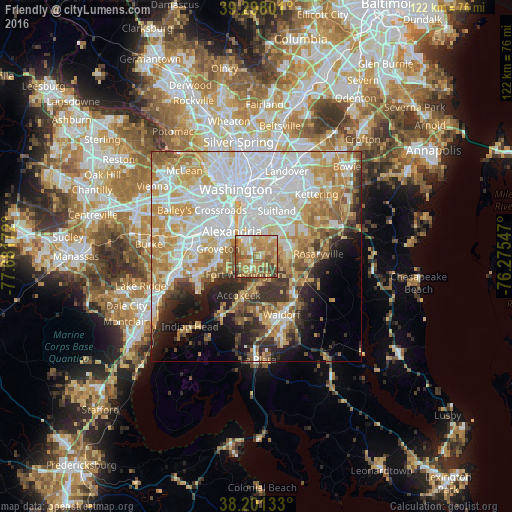
Analysis of Friendly night lights 2016
Square area 10x10 km:
 7.48%
7.48%90-99
9.18%80-89
16.67%70-79
23.81%60-69
18.37%50-59
12.07%40-49
10.03%30-39
2.38%20-29
0%10-19
0%0-9
0%Square area 50x50 km:
18.96%90-99
12.47%80-89
8.65%70-79
10.63%60-69
6.95%50-59
5.35%40-49
3.62%30-39
4.55%20-29
5.75%10-19
7.56%0-9
15.51%Clear (daylight) street map image can be seen on geolist.org.
Map coordinates:
39° 17' 52.8" North, 77° 40' 54.2" West
38° 45' 6.4" North, 76° 58' 42.9" West
38° 12' 4.8" North, 76° 16' 31.7" West
Some cities around Friendly sort by population:
• Clinton
7.1 km =4.4 mi,  77°
77°
• Oxon Hill-Glassmanor
4.9 km =3 mi,  3°
3°
• Fort Washington
6.3 km =3.9 mi,  217°
217°
• Oxon Hill
5.8 km =3.6 mi,  350°
350°
• Glassmanor
7.7 km =4.8 mi, 346°
• Fort Hunt
7.2 km =4.5 mi,  253°
253°
• Temple Hills
7.5 km =4.7 mi,  22°
22°
• Belle Haven
8.2 km =5.1 mi,  297°
297°
4355670 (p: 9,250)
Sources (retrieved 2019-11-25):
» Earth at Night: Flat Maps 2012, 2016