Silver Hill night lights from space
Night Light of Silver Hill (Maryland) from space (United States) Src. Average luminocity for 10x10km area is 97.7211% and for 50x50km: 67.9191%.
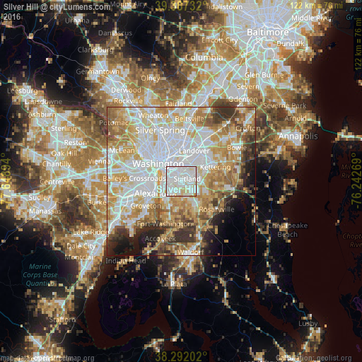
Analysis of Silver Hill night lights 2016
Square area 10x10 km:
 52.04%
90-99
39.8%80-89
7.65%70-79
0.51%60-69
0%50-59
0%40-49
0%30-39
0%20-29
0%10-19
0%0-9
0%Square area 50x50 km:
21.7%90-99
15.4%80-89
10.59%70-79
11.12%60-69
7.96%50-59
6.45%40-49
3.87%30-39
4.94%20-29
4.35%10-19
5.06%0-9
8.55%Clear (daylight) street map image can be seen on geolist.org.
Map coordinates:
39° 23' 14.4" North, 77° 38' 56.2" West
38° 50' 30.4" North, 76° 56' 44.9" West
38° 17' 31.3" North, 76° 14' 33.7" West
Some cities around Silver Hill sort by population:
• Suitland-Silver Hill
1.8 km =1.1 mi,  71°
71°
• Suitland
2.1 km =1.3 mi, 67°
• Glassmanor
5.2 km =3.2 mi,  241°
241°
• Hillcrest Heights
1.5 km =0.9 mi,  230°
230°
• Coral Hills
3.8 km =2.4 mi,  33°
33°
• Temple Hills
3.1 km =1.9 mi,  179°
179°
• District Heights
5.2 km =3.2 mi, 70°
• Marlow Heights
1.1 km =0.7 mi,  208°
208°
4369571 (p: 5,950)
Sources (retrieved 2019-11-25):
» Earth at Night: Flat Maps 2012, 2016