Glassmanor night lights from space
Night Light of Glassmanor (Maryland) from space (United States) Src. Average luminocity for 10x10km area is 93.1565% and for 50x50km: 69.7278%.
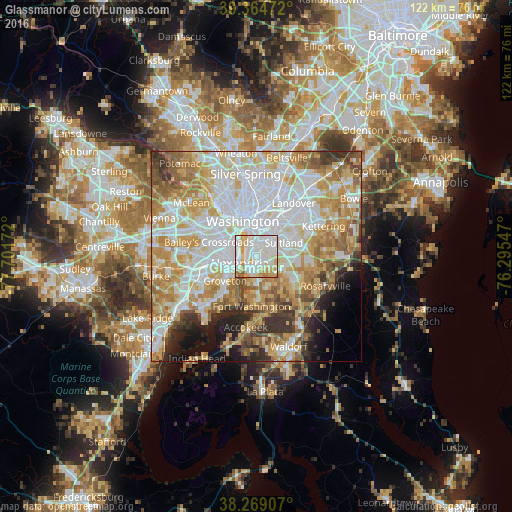
Analysis of Glassmanor night lights 2016
Square area 10x10 km:
 36.9%
36.9%90-99
38.1%80-89
11.56%70-79
8.33%60-69
3.74%50-59
1.19%40-49
0.17%30-39
0%20-29
0%10-19
0%0-9
0%Square area 50x50 km:
21.92%90-99
15.68%80-89
10.75%70-79
12.5%60-69
8.76%50-59
6.33%40-49
3.87%30-39
4.36%20-29
4.26%10-19
5.07%0-9
6.49%Clear (daylight) street map image can be seen on geolist.org.
Map coordinates:
39° 21' 53" North, 77° 42' 6.2" West
38° 49' 8.4" North, 76° 59' 54.9" West
38° 16' 8.7" North, 76° 17' 43.7" West
Some cities around Glassmanor sort by population:
• Alexandria
4.5 km =2.8 mi,  249°
249°
• Oxon Hill-Glassmanor
3.3 km =2.1 mi,  141°
141°
• Oxon Hill
1.9 km =1.2 mi,  155°
155°
• Hillcrest Heights
3.7 km =2.3 mi,  65°
65°
• Temple Hills
4.6 km =2.9 mi,  96°
96°
• Belle Haven
6.7 km =4.2 mi,  236°
236°
• Silver Hill
5.2 km =3.2 mi,  61°
61°
• Marlow Heights
4.4 km =2.7 mi, 68°
4356165 (p: 17,295)
Sources (retrieved 2019-11-25):
» Earth at Night: Flat Maps 2012, 2016