Oak Grove night lights from space
Night Light of Oak Grove (Minnesota) from space (United States) Src. Average luminocity for 10x10km area is 3.1238% and for 50x50km: 16.58%.
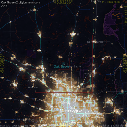
Analysis of Oak Grove night lights 2016
Square area 10x10 km:
 0%
0%90-99
0%80-89
0.63%70-79
0%60-69
0.63%50-59
0.95%40-49
0%30-39
0.63%20-29
1.59%10-19
0%0-9
95.56%Square area 50x50 km:
2.25%90-99
2.36%80-89
1.69%70-79
1.98%60-69
2.77%50-59
2.83%40-49
3.15%30-39
2.68%20-29
4.6%10-19
10.47%0-9
65.23%Clear (daylight) street map image can be seen on geolist.org.
Map coordinates:
45° 49' 58.3" North, 94° 1' 48.1" West
45° 20' 26.9" North, 93° 19' 36.8" West
44° 50' 39.9" North, 92° 37' 25.6" West
Some cities around Oak Grove sort by population:
• Andover
12.3 km =7.6 mi,  166°
166°
• Ramsey
13.1 km =8.1 mi,  227°
227°
• Champlin
17.8 km =11.1 mi,  198°
198°
• Anoka
16.6 km =10.3 mi, 196°
• Ham Lake
11.7 km =7.3 mi,  149°
149°
• East Bethel
10 km =6.2 mi,  103°
103°
• Saint Francis
5.7 km =3.5 mi,  333°
333°
• Isanti
17.7 km =11 mi,  20°
20°
5039857 (p: 8,439)
Sources (retrieved 2019-11-25):
» Earth at Night: Flat Maps 2012, 2016