Anoka night lights from space
Night Light of Anoka (Minnesota) from space (United States) Src. Average luminocity for 10x10km area is 66.8273% and for 50x50km: 35.8257%.
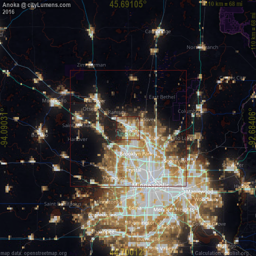
Analysis of Anoka night lights 2016
Square area 10x10 km:
 14.39%
90-99
11.82%80-89
10.3%70-79
13.03%60-69
10.15%50-59
13.03%40-49
5.76%30-39
10.3%20-29
11.06%10-19
0.15%0-9
0%Square area 50x50 km:
8.92%90-99
7.56%80-89
4.26%70-79
4.52%60-69
5.45%50-59
4.43%40-49
4.18%30-39
3.14%20-29
5.5%10-19
10.98%0-9
41.05%Clear (daylight) street map image can be seen on geolist.org.
Map coordinates:
45° 41' 27.8" North, 94° 5' 25.1" West
45° 11' 51.9" North, 93° 23' 13.8" West
44° 42' 0.4" North, 92° 41' 2.6" West
Some cities around Anoka sort by population:
• Brooklyn Park
11.8 km =7.3 mi,  168°
168°
• West Coon Rapids
5.2 km =3.2 mi,  145°
145°
• Coon Rapids
11.6 km =7.2 mi,  137°
137°
• Andover
8.5 km =5.3 mi,  62°
62°
• Ramsey
8.6 km =5.3 mi,  325°
325°
• Champlin
1.3 km =0.8 mi,  219°
219°
• Ham Lake
12.2 km =7.6 mi, 61°
• Dayton
11.2 km =7 mi,  297°
297°
5016450 (p: 17,350)
Sources (retrieved 2019-11-25):
» Earth at Night: Flat Maps 2012, 2016