Isanti night lights from space
Night Light of Isanti (Minnesota) from space (United States) Src. Average luminocity for 10x10km area is 8% and for 50x50km: 4.1744%.
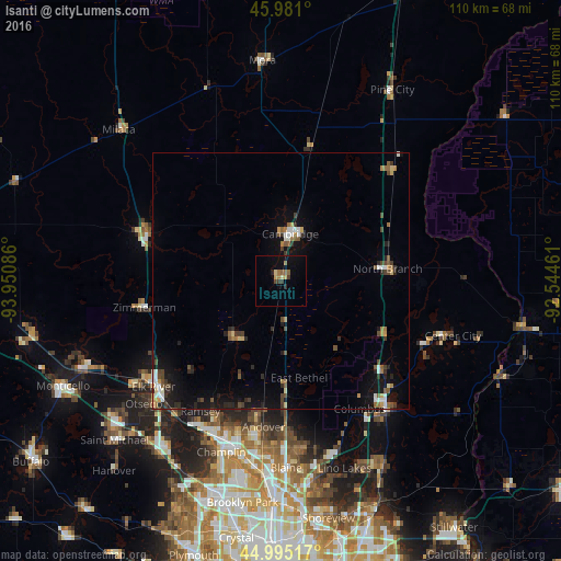
Analysis of Isanti night lights 2016
Square area 10x10 km:
 0%
0%90-99
0.16%80-89
1.11%70-79
1.27%60-69
1.59%50-59
2.22%40-49
0.95%30-39
1.43%20-29
0.95%10-19
3.02%0-9
87.3%Square area 50x50 km:
0.42%90-99
0.47%80-89
0.28%70-79
0.36%60-69
0.57%50-59
0.69%40-49
0.79%30-39
0.71%20-29
1.1%10-19
3.31%0-9
91.31%Clear (daylight) street map image can be seen on geolist.org.
Map coordinates:
45° 58' 51.6" North, 93° 57' 3.1" West
45° 29' 24.9" North, 93° 14' 51.8" West
44° 59' 42.6" North, 92° 32' 40.6" West
Some cities around Isanti sort by population:
• Ham Lake
26.7 km =16.6 mi,  180°
180°
• East Bethel
19.3 km =12 mi,  169°
169°
• North Branch
21 km =13 mi,  83°
83°
• Cambridge
9.4 km =5.8 mi,  11°
11°
• Oak Grove
17.7 km =11 mi,  200°
200°
• Wyoming
26 km =16.2 mi,  131°
131°
• Saint Francis
14.4 km =8.9 mi,  217°
217°
• Zimmerman
27.2 km =16.9 mi,  258°
258°
5031489 (p: 5,464)
Sources (retrieved 2019-11-25):
» Earth at Night: Flat Maps 2012, 2016