East Bethel night lights from space
Night Light of East Bethel (Minnesota) from space (United States) Src. Average luminocity for 10x10km area is 3.9159% and for 50x50km: 17.0663%.
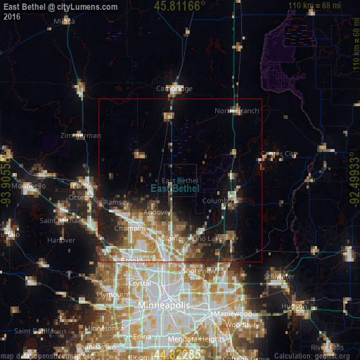
Analysis of East Bethel night lights 2016
Square area 10x10 km:
 0%
0%90-99
0%80-89
0.63%70-79
0%60-69
1.11%50-59
1.11%40-49
1.75%30-39
0.16%20-29
1.11%10-19
0.79%0-9
93.33%Square area 50x50 km:
2.63%90-99
2.62%80-89
1.66%70-79
2.25%60-69
2.96%50-59
2.88%40-49
3.2%30-39
2.66%20-29
4.14%10-19
7.96%0-9
67.04%Clear (daylight) street map image can be seen on geolist.org.
Map coordinates:
45° 48' 42" North, 93° 54' 20.1" West
45° 19' 9.9" North, 93° 12' 8.8" West
44° 49' 22.3" North, 92° 29' 57.6" West
Some cities around East Bethel sort by population:
• Blaine
17.8 km =11.1 mi,  188°
188°
• Andover
11.8 km =7.3 mi,  215°
215°
• Forest Lake
17.6 km =10.9 mi,  104°
104°
• Ham Lake
8.5 km =5.3 mi,  205°
205°
• Oak Grove
10 km =6.2 mi,  283°
283°
• Wyoming
16.2 km =10.1 mi,  83°
83°
• Saint Francis
14.4 km =8.9 mi,  301°
301°
• Isanti
19.3 km =12 mi,  349°
349°
5024937 (p: 11,692)
Sources (retrieved 2019-11-25):
» Earth at Night: Flat Maps 2012, 2016