Saint Francis night lights from space
Night Light of Saint Francis (Minnesota) from space (United States) Src. Average luminocity for 10x10km area is 5.3175% and for 50x50km: 12.4236%.
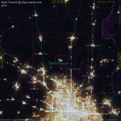
Analysis of Saint Francis night lights 2016
Square area 10x10 km:
 0%
0%90-99
0%80-89
1.75%70-79
0.16%60-69
1.43%50-59
1.11%40-49
0.48%30-39
2.06%20-29
1.75%10-19
0.16%0-9
91.11%Square area 50x50 km:
1.47%90-99
1.59%80-89
1.29%70-79
1.19%60-69
1.84%50-59
2.38%40-49
2.4%30-39
2.32%20-29
3.82%10-19
8.84%0-9
72.87%Clear (daylight) street map image can be seen on geolist.org.
Map coordinates:
45° 52' 42.9" North, 94° 3' 45.1" West
45° 23' 12.9" North, 93° 21' 33.8" West
44° 53' 27.4" North, 92° 39' 22.6" West
Some cities around Saint Francis sort by population:
• Andover
17.9 km =11.1 mi,  162°
162°
• Ramsey
15.7 km =9.8 mi,  206°
206°
• Elk River
18.7 km =11.6 mi,  240°
240°
• Ham Lake
17.4 km =10.8 mi,  150°
150°
• East Bethel
14.4 km =8.9 mi,  121°
121°
• Oak Grove
5.7 km =3.5 mi, 153°
• Isanti
14.4 km =8.9 mi,  37°
37°
• Zimmerman
19.1 km =11.9 mi,  289°
289°
5044485 (p: 7,218)
Sources (retrieved 2019-11-25):
» Earth at Night: Flat Maps 2012, 2016