Mountain House night lights from space
Night Light of Mountain House (California) from space (United States) Src. Average luminocity for 10x10km area is 23.6871% and for 50x50km: 20.5901%.
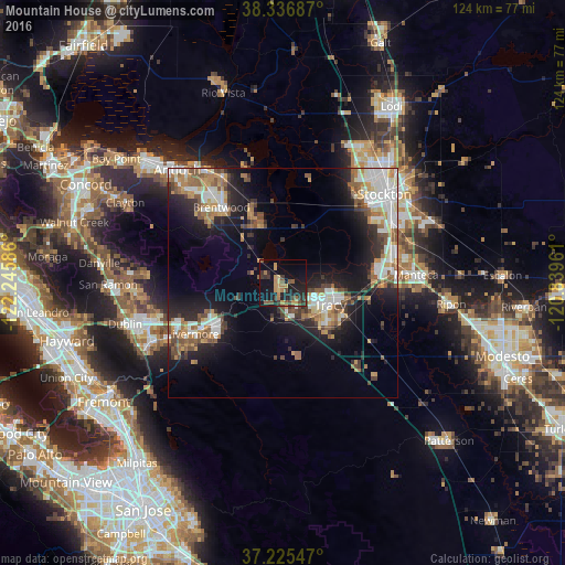
Analysis of Mountain House night lights 2016
Square area 10x10 km:
 0%
0%90-99
0%80-89
1.7%70-79
7.65%60-69
4.42%50-59
4.25%40-49
4.42%30-39
5.61%20-29
7.99%10-19
27.89%0-9
36.05%Square area 50x50 km:
3.65%90-99
3.75%80-89
1.38%70-79
3.13%60-69
2.98%50-59
3.26%40-49
2.75%30-39
2.53%20-29
5.14%10-19
12.36%0-9
59.08%Clear (daylight) street map image can be seen on geolist.org.
Map coordinates:
38° 20' 12.7" North, 122° 14' 45.1" West
37° 46' 59.7" North, 121° 32' 33.8" West
37° 13' 31.7" North, 120° 50' 22.6" West
Some cities around Mountain House sort by population:
• Livermore
22.8 km =14.2 mi,  240°
240°
• Tracy
11.3 km =7 mi,  115°
115°
• Manteca
28.7 km =17.8 mi,  86°
86°
• Brentwood
21.3 km =13.2 mi,  320°
320°
• Oakley
28.1 km =17.5 mi,  327°
327°
• Lathrop
23.8 km =14.8 mi,  79°
79°
• Discovery Bay
14.8 km =9.2 mi,  340°
340°
• Country Club
27.2 km =16.9 mi,  40°
40°
5375407 (p: 9,675)
Sources (retrieved 2019-11-25):
» Earth at Night: Flat Maps 2012, 2016