Oakley night lights from space
Night Light of Oakley (California) from space (United States) Src. Average luminocity for 10x10km area is 46.6948% and for 50x50km: 13.5531%.

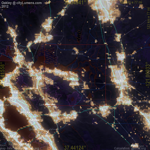
Analysis of Oakley night lights 2016
Square area 10x10 km:
 6.82%
6.82%90-99
8.44%80-89
3.08%70-79
10.55%60-69
8.44%50-59
12.18%40-49
3.25%30-39
4.22%20-29
11.53%10-19
23.38%0-9
8.12%Square area 50x50 km:
1.33%90-99
1.61%80-89
0.48%70-79
2.4%60-69
2.49%50-59
3.01%40-49
2.29%30-39
1.93%20-29
5.21%10-19
9.53%0-9
69.72%Clear (daylight) street map image can be seen on geolist.org.
Map coordinates:
38° 32' 57.9" North, 122° 24' 56.1" West
37° 59' 50.7" North, 121° 42' 44.8" West
37° 26' 28.5" North, 121° 0' 33.6" West
Some cities around Oakley sort by population:
• Antioch
8.2 km =5.1 mi,  275°
275°
• Pittsburg
15.5 km =9.6 mi, 282°
• Brentwood
7.4 km =4.6 mi,  168°
168°
• Bay Point
22.1 km =13.7 mi, 279°
• Discovery Bay
13.9 km =8.6 mi,  135°
135°
• Clayton
20.6 km =12.8 mi,  252°
252°
• Blackhawk
26.1 km =16.2 mi,  221°
221°
• Rio Vista
18.6 km =11.6 mi,  4°
4°
5378566 (p: 39,813)
Sources (retrieved 2019-11-25):
» Earth at Night: Flat Maps 2012, 2016