Lathrop night lights from space
Night Light of Lathrop (California) from space (United States) Src. Average luminocity for 10x10km area is 65.3741% and for 50x50km: 25.2924%.
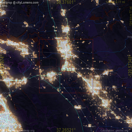

Analysis of Lathrop night lights 2016
Square area 10x10 km:
 15.31%
90-99
13.95%80-89
4.76%70-79
12.24%60-69
12.93%50-59
12.07%40-49
8.33%30-39
4.93%20-29
8.5%10-19
6.97%0-9
0%Square area 50x50 km:
4.54%90-99
4.82%80-89
2.09%70-79
4.06%60-69
3.37%50-59
3.36%40-49
3.79%30-39
3.86%20-29
6.52%10-19
12.9%0-9
50.68%Clear (daylight) street map image can be seen on geolist.org.
Map coordinates:
38° 22' 33.6" North, 121° 58' 47.1" West
37° 49' 21.7" North, 121° 16' 35.8" West
37° 15' 54.8" North, 120° 34' 24.6" West
Some cities around Lathrop sort by population:
• Stockton
15.1 km =9.4 mi,  355°
355°
• Tracy
16 km =9.9 mi,  234°
234°
• Manteca
6 km =3.7 mi,  117°
117°
• Ripon
16.1 km =10 mi, 123°
• Salida
21.3 km =13.2 mi,  127°
127°
• Garden Acres
16.2 km =10.1 mi,  14°
14°
• Country Club
17.2 km =10.7 mi,  340°
340°
• August
17.4 km =10.8 mi,  4°
4°
5365425 (p: 20,866)
Sources (retrieved 2019-11-25):
» Earth at Night: Flat Maps 2012, 2016