Mount Dora night lights from space
Night Light of Mount Dora (Florida) from space (United States) Src. Average luminocity for 10x10km area is 57.5682% and for 50x50km: 32.0295%.
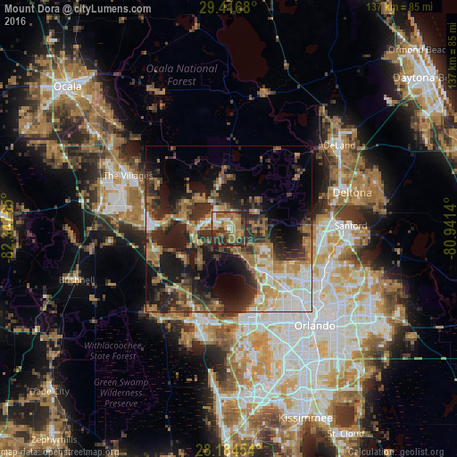
Analysis of Mount Dora night lights 2016
Square area 10x10 km:
 5.3%
5.3%90-99
6.44%80-89
8.33%70-79
6.25%60-69
27.08%50-59
7.39%40-49
10.23%30-39
14.39%20-29
14.39%10-19
0.19%0-9
0%Square area 50x50 km:
3.52%90-99
5.29%80-89
2.86%70-79
2.93%60-69
10.09%50-59
3.67%40-49
4.59%30-39
7.68%20-29
10.32%10-19
15.72%0-9
33.33%Clear (daylight) street map image can be seen on geolist.org.
Map coordinates:
29° 25' 0.5" North, 82° 20' 51.5" West
28° 48' 9" North, 81° 38' 40.3" West
28° 11' 4.3" North, 80° 56' 29" West
Some cities around Mount Dora sort by population:
• Apopka
19.1 km =11.9 mi,  137°
137°
• Wekiwa Springs
24.3 km =15.1 mi,  118°
118°
• Leesburg
22.8 km =14.2 mi,  272°
272°
• Eustis
6.9 km =4.3 mi,  324°
324°
• Tavares
7.9 km =4.9 mi, 271°
• Forest City
24.7 km =15.3 mi,  127°
127°
• Heathrow
26.9 km =16.7 mi,  99°
99°
• South Apopka
20.4 km =12.7 mi, 139°
4165069 (p: 13,519)
Sources (retrieved 2019-11-25):
» Earth at Night: Flat Maps 2012, 2016