Forest City night lights from space
Night Light of Forest City (Florida) from space (United States) Src. Average luminocity for 10x10km area is 88.7045% and for 50x50km: 64.4598%.
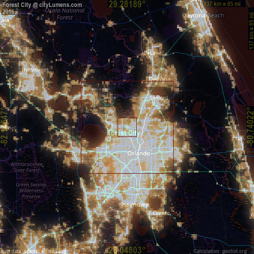
Analysis of Forest City night lights 2016
Square area 10x10 km:
 23.48%
90-99
35.23%80-89
15.15%70-79
14.39%60-69
11.17%50-59
0.57%40-49
0%30-39
0%20-29
0%10-19
0%0-9
0%Square area 50x50 km:
18.76%90-99
17.98%80-89
7.85%70-79
8.31%60-69
9.84%50-59
4.1%40-49
3.89%30-39
5.73%20-29
7.29%10-19
7.06%0-9
9.18%Clear (daylight) street map image can be seen on geolist.org.
Map coordinates:
29° 16' 54.8" North, 82° 8' 47.3" West
28° 40' 0.4" North, 81° 26' 36" West
28° 2' 52.9" North, 80° 44' 24.8" West
Some cities around Forest City sort by population:
• Apopka
6.8 km =4.2 mi,  278°
278°
• Altamonte Springs
7.6 km =4.7 mi,  94°
94°
• Wekiwa Springs
3.9 km =2.4 mi,  26°
26°
• Maitland
8.9 km =5.5 mi,  118°
118°
• Lockhart
5.3 km =3.3 mi,  179°
179°
• Fairview Shores
9.7 km =6 mi,  150°
150°
• Fern Park
9.2 km =5.7 mi,  102°
102°
• South Apopka
6.5 km =4 mi,  265°
265°
4155824 (p: 13,854)
Sources (retrieved 2019-11-25):
» Earth at Night: Flat Maps 2012, 2016