South Apopka night lights from space
Night Light of South Apopka (Florida) from space (United States) Src. Average luminocity for 10x10km area is 84.3636% and for 50x50km: 62.7285%.
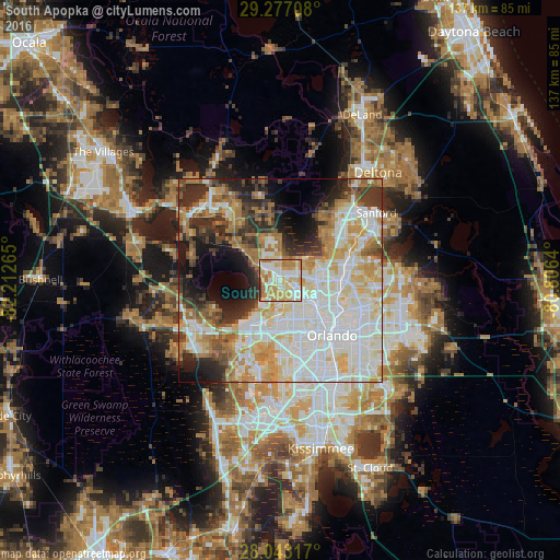
Analysis of South Apopka night lights 2016
Square area 10x10 km:
 18.56%
90-99
25.38%80-89
17.99%70-79
20.08%60-69
14.2%50-59
1.89%40-49
0.38%30-39
1.52%20-29
0%10-19
0%0-9
0%Square area 50x50 km:
18.12%90-99
17.08%80-89
7.71%70-79
7.74%60-69
9.56%50-59
3.98%40-49
3.97%30-39
6.26%20-29
7.87%10-19
8.18%0-9
9.54%Clear (daylight) street map image can be seen on geolist.org.
Map coordinates:
29° 16' 37.5" North, 82° 12' 45.5" West
28° 39' 43" North, 81° 30' 34.3" West
28° 2' 35.4" North, 80° 48' 23" West
Some cities around South Apopka sort by population:
• Pine Hills
12.8 km =8 mi,  154°
154°
• Apopka
1.6 km =1 mi,  351°
351°
• Ocoee
10.8 km =6.7 mi,  198°
198°
• Winter Garden
13.1 km =8.1 mi,  214°
214°
• Wekiwa Springs
9.1 km =5.7 mi,  63°
63°
• Forest City
6.5 km =4 mi,  85°
85°
• Lockhart
8.1 km =5 mi,  125°
125°
• Fairview Shores
13.7 km =8.5 mi,  124°
124°
4173394 (p: 5,728)
Sources (retrieved 2019-11-25):
» Earth at Night: Flat Maps 2012, 2016