Heathrow night lights from space
Night Light of Heathrow (Florida) from space (United States) Src. Average luminocity for 10x10km area is 74.2348% and for 50x50km: 51.2404%.
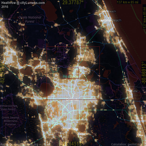
Analysis of Heathrow night lights 2016
Square area 10x10 km:
 14.58%
90-99
17.99%80-89
8.14%70-79
20.08%60-69
20.08%50-59
4.55%40-49
4.17%30-39
4.92%20-29
5.3%10-19
0.19%0-9
0%Square area 50x50 km:
11.97%90-99
12.96%80-89
5.76%70-79
6.66%60-69
11.28%50-59
4.38%40-49
3.57%30-39
5.73%20-29
7.02%10-19
8.8%0-9
21.86%Clear (daylight) street map image can be seen on geolist.org.
Map coordinates:
29° 22' 40.3" North, 82° 4' 31.4" West
28° 45' 48" North, 81° 22' 20.1" West
28° 8' 42.5" North, 80° 40' 8.9" West
Some cities around Heathrow sort by population:
• Sanford
10.5 km =6.5 mi,  66°
66°
• Altamonte Springs
11.4 km =7.1 mi,  176°
176°
• Winter Springs
9.5 km =5.9 mi,  138°
138°
• Casselberry
10.5 km =6.5 mi,  155°
155°
• Wekiwa Springs
8.9 km =5.5 mi,  215°
215°
• Lake Mary
5.3 km =3.3 mi,  95°
95°
• Longwood
7.5 km =4.7 mi,  153°
153°
• Forest City
12.8 km =8 mi,  212°
212°
4158296 (p: 5,896)
Sources (retrieved 2019-11-25):
» Earth at Night: Flat Maps 2012, 2016