Tavares night lights from space
Night Light of Tavares (Florida) from space (United States) Src. Average luminocity for 10x10km area is 53.6989% and for 50x50km: 31.444%.
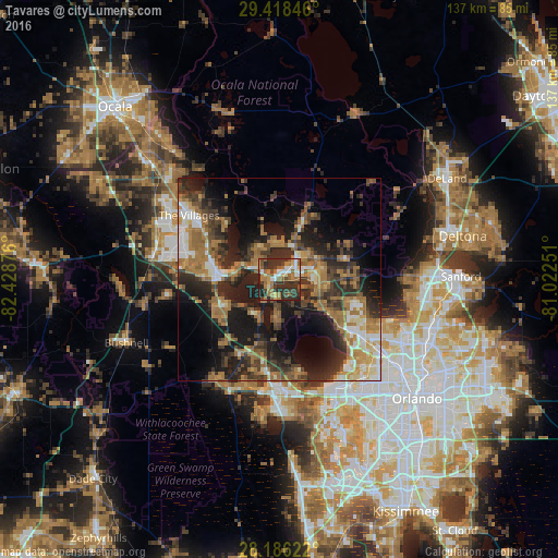
Analysis of Tavares night lights 2016
Square area 10x10 km:
 6.63%
6.63%90-99
7.39%80-89
5.11%70-79
3.79%60-69
18.56%50-59
10.42%40-49
6.82%30-39
18.18%20-29
21.97%10-19
1.14%0-9
0%Square area 50x50 km:
3.05%90-99
4.06%80-89
2.68%70-79
3.06%60-69
11.05%50-59
4.17%40-49
4.73%30-39
7.7%20-29
10.92%10-19
16.08%0-9
32.49%Clear (daylight) street map image can be seen on geolist.org.
Map coordinates:
29° 25' 6.5" North, 82° 25' 43.5" West
28° 48' 15" North, 81° 43' 32.3" West
28° 11' 10.4" North, 81° 1' 21" West
Some cities around Tavares sort by population:
• The Villages
27 km =16.8 mi,  302°
302°
• Apopka
25.2 km =15.7 mi,  124°
124°
• Leesburg
14.9 km =9.3 mi,  272°
272°
• Eustis
6.7 km =4.2 mi,  35°
35°
• Lady Lake
23 km =14.3 mi, 303°
• Mount Dora
7.9 km =4.9 mi,  91°
91°
• Minneola
25.6 km =15.9 mi,  184°
184°
• South Apopka
26.3 km =16.3 mi,  126°
126°
4174861 (p: 15,430)
Sources (retrieved 2019-11-25):
» Earth at Night: Flat Maps 2012, 2016