Middlebury night lights from space
Night Light of Middlebury (Connecticut) from space (United States) Src. Average luminocity for 10x10km area is 29.5442% and for 50x50km: 28.2838%.
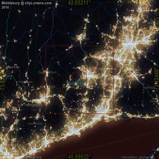
Analysis of Middlebury night lights 2016
Square area 10x10 km:
 0.68%
0.68%90-99
2.72%80-89
3.57%70-79
6.97%60-69
4.93%50-59
2.72%40-49
6.29%30-39
6.46%20-29
13.61%10-19
23.98%0-9
28.06%Square area 50x50 km:
2.82%90-99
3.41%80-89
3.86%70-79
4.06%60-69
4.95%50-59
6.07%40-49
6.35%30-39
5.72%20-29
7.6%10-19
12.2%0-9
42.97%Clear (daylight) street map image can be seen on geolist.org.
Map coordinates:
42° 3' 7.6" North, 73° 49' 50.7" West
41° 31' 40.3" North, 73° 7' 39.4" West
40° 59' 57.7" North, 72° 25' 28.2" West
Some cities around Middlebury sort by population:
• Waterbury
7.2 km =4.5 mi,  62°
62°
• Naugatuck
7.9 km =4.9 mi,  126°
126°
• Southbury
8.8 km =5.5 mi,  234°
234°
• Wolcott
14.3 km =8.9 mi,  54°
54°
• Oxford
10.5 km =6.5 mi,  175°
175°
• Woodbury
7 km =4.3 mi,  285°
285°
• Prospect
12.7 km =7.9 mi,  102°
102°
• Oakville
8.1 km =5 mi,  25°
25°
4838611 (p: 6,974)
Sources (retrieved 2019-11-25):
» Earth at Night: Flat Maps 2012, 2016