Wolcott night lights from space
Night Light of Wolcott (Connecticut) from space (United States) Src. Average luminocity for 10x10km area is 46.3409% and for 50x50km: 34.8483%.
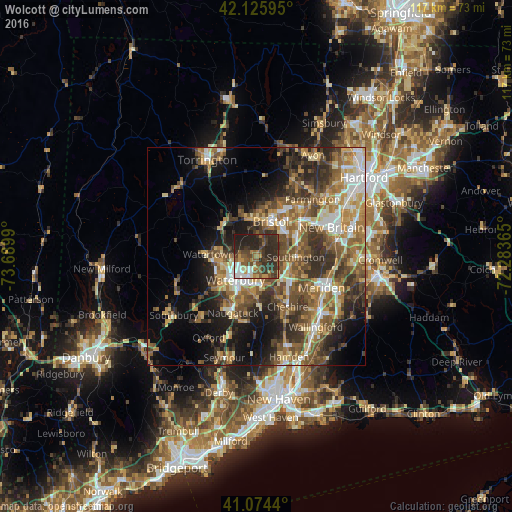
Analysis of Wolcott night lights 2016
Square area 10x10 km:
 5.36%
5.36%90-99
5.84%80-89
2.6%70-79
5.68%60-69
6.33%50-59
10.06%40-49
12.01%30-39
16.72%20-29
29.87%10-19
5.52%0-9
0%Square area 50x50 km:
4.03%90-99
4.44%80-89
4.71%70-79
5.61%60-69
6.48%50-59
7.66%40-49
7.2%30-39
6.95%20-29
8.32%10-19
10.85%0-9
33.75%Clear (daylight) street map image can be seen on geolist.org.
Map coordinates:
42° 7' 33.4" North, 73° 41' 23.6" West
41° 36' 8.4" North, 72° 59' 12.4" West
41° 4' 27.8" North, 72° 17' 1.1" West
Some cities around Wolcott sort by population:
• Waterbury
7.3 km =4.5 mi,  227°
227°
• Bristol
8.3 km =5.2 mi,  21°
21°
• Plainville
13.4 km =8.3 mi,  53°
53°
• Plymouth
9.5 km =5.9 mi,  324°
324°
• Prospect
11.1 km =6.9 mi,  176°
176°
• Oakville
8.3 km =5.2 mi,  263°
263°
• Cheshire Village
13.3 km =8.3 mi,  146°
146°
• Terryville
8.7 km =5.4 mi,  346°
346°
4845984 (p: 16,639)
Sources (retrieved 2019-11-25):
» Earth at Night: Flat Maps 2012, 2016