Prospect night lights from space
Night Light of Prospect (Connecticut) from space (United States) Src. Average luminocity for 10x10km area is 40.5119% and for 50x50km: 39.2903%.
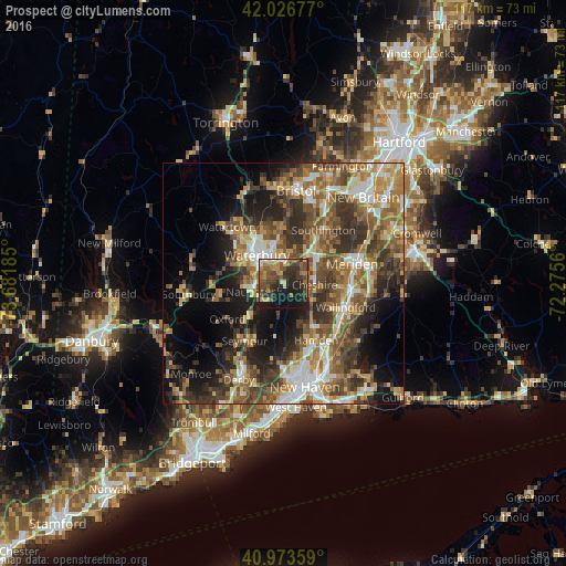
Analysis of Prospect night lights 2016
Square area 10x10 km:
 1.7%
1.7%90-99
1.87%80-89
4.08%70-79
8.16%60-69
6.97%50-59
10.54%40-49
12.41%30-39
11.39%20-29
17.69%10-19
24.32%0-9
0.85%Square area 50x50 km:
4.77%90-99
5.59%80-89
4.92%70-79
6.19%60-69
7.22%50-59
8.49%40-49
8.31%30-39
7.87%20-29
9.04%10-19
12.1%0-9
25.5%Clear (daylight) street map image can be seen on geolist.org.
Map coordinates:
42° 1' 36.4" North, 73° 40' 54.7" West
41° 30' 8.4" North, 72° 58' 43.4" West
40° 58' 24.9" North, 72° 16' 32.2" West
Some cities around Prospect sort by population:
• Waterbury
8.7 km =5.4 mi,  315°
315°
• Hamden
13.7 km =8.5 mi,  149°
149°
• Naugatuck
6.3 km =3.9 mi,  253°
253°
• Cheshire
6.5 km =4 mi,  93°
93°
• Wolcott
11.1 km =6.9 mi,  356°
356°
• Oakville
13.5 km =8.4 mi, 318°
• Middlebury
12.7 km =7.9 mi,  282°
282°
• Cheshire Village
6.6 km =4.1 mi, 89°
4841089 (p: 9,476)
Sources (retrieved 2019-11-25):
» Earth at Night: Flat Maps 2012, 2016