Woodbury night lights from space
Night Light of Woodbury (Connecticut) from space (United States) Src. Average luminocity for 10x10km area is 8.3554% and for 50x50km: 21.5203%.
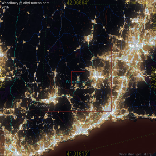
Analysis of Woodbury night lights 2016
Square area 10x10 km:
 0%
0%90-99
0%80-89
0.51%70-79
1.19%60-69
2.04%50-59
0.68%40-49
2.04%30-39
2.04%20-29
0.68%10-19
2.89%0-9
87.93%Square area 50x50 km:
2.12%90-99
2.64%80-89
2.81%70-79
2.86%60-69
3.13%50-59
3.47%40-49
4.4%30-39
4.19%20-29
7.95%10-19
13.56%0-9
52.89%Clear (daylight) street map image can be seen on geolist.org.
Map coordinates:
42° 4' 7.1" North, 73° 54' 43.7" West
41° 32' 40.3" North, 73° 12' 32.4" West
41° 0' 58.1" North, 72° 30' 21.2" West
Some cities around Woodbury sort by population:
• Waterbury
13.2 km =8.2 mi,  83°
83°
• Naugatuck
14.7 km =9.1 mi,  116°
116°
• Southbury
7 km =4.3 mi,  182°
182°
• Plymouth
19.2 km =11.9 mi,  42°
42°
• Oxford
14.5 km =9 mi,  147°
147°
• Oakville
11.6 km =7.2 mi,  62°
62°
• Middlebury
7 km =4.3 mi,  105°
105°
• New Milford
17 km =10.6 mi,  282°
282°
4846028 (p: 9,755)
Sources (retrieved 2019-11-25):
» Earth at Night: Flat Maps 2012, 2016