Oakville night lights from space
Night Light of Oakville (Connecticut) from space (United States) Src. Average luminocity for 10x10km area is 50.9545% and for 50x50km: 26.7914%.
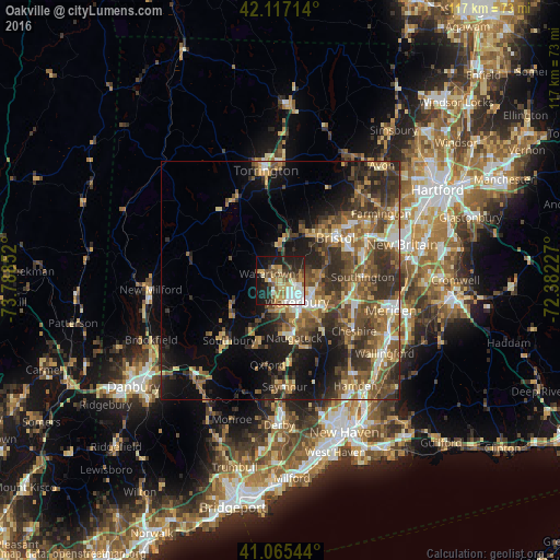
Analysis of Oakville night lights 2016
Square area 10x10 km:
 8.77%
8.77%90-99
10.55%80-89
8.77%70-79
8.12%60-69
2.92%50-59
8.44%40-49
8.28%30-39
3.57%20-29
15.91%10-19
21.75%0-9
2.92%Square area 50x50 km:
2.39%90-99
2.71%80-89
3.61%70-79
3.79%60-69
4.73%50-59
6.33%40-49
6.19%30-39
6.28%20-29
8%10-19
11.17%0-9
44.8%Clear (daylight) street map image can be seen on geolist.org.
Map coordinates:
42° 7' 1.7" North, 73° 47' 18.7" West
41° 35' 36.3" North, 73° 5' 7.4" West
41° 3' 55.6" North, 72° 22' 56.2" West
Some cities around Oakville sort by population:
• Waterbury
4.8 km =3 mi,  144°
144°
• Naugatuck
12.3 km =7.6 mi,  166°
166°
• Wolcott
8.3 km =5.2 mi,  83°
83°
• Plymouth
9.1 km =5.7 mi,  17°
17°
• Woodbury
11.6 km =7.2 mi,  242°
242°
• Prospect
13.5 km =8.4 mi, 138°
• Middlebury
8.1 km =5 mi,  205°
205°
• Terryville
11.3 km =7 mi,  33°
33°
4839921 (p: 9,047)
Sources (retrieved 2019-11-25):
» Earth at Night: Flat Maps 2012, 2016