Mayflower Village night lights from space
Night Light of Mayflower Village (California) from space (United States) Src. Average luminocity for 10x10km area is 90.8297% and for 50x50km: 59.68%.
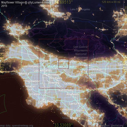
Analysis of Mayflower Village night lights 2016
Square area 10x10 km:
 32.97%
90-99
34.07%80-89
13.74%70-79
11.9%60-69
3.11%50-59
4.21%40-49
0%30-39
0%20-29
0%10-19
0%0-9
0%Square area 50x50 km:
25.22%90-99
15.58%80-89
5.53%70-79
7.63%60-69
6.39%50-59
3.66%40-49
2.31%30-39
1.45%20-29
1.91%10-19
4.06%0-9
26.25%Clear (daylight) street map image can be seen on geolist.org.
Map coordinates:
34° 41' 42.5" North, 118° 42' 46.5" West
34° 6' 54" North, 118° 0' 35.2" West
33° 31' 51.2" North, 117° 18' 24" West
Some cities around Mayflower Village sort by population:
• El Monte
5.4 km =3.4 mi,  197°
197°
• Baldwin Park
5.6 km =3.5 mi,  126°
126°
• Arcadia
3.6 km =2.2 mi,  319°
319°
• Monrovia
3.8 km =2.4 mi,  15°
15°
• Temple City
4.5 km =2.8 mi,  258°
258°
• Duarte
4 km =2.5 mi,  47°
47°
• Sierra Madre
6.5 km =4 mi, 322°
• East Pasadena
6.4 km =4 mi,  293°
293°
5371243 (p: 5,515)
Sources (retrieved 2019-11-25):
» Earth at Night: Flat Maps 2012, 2016