Sierra Madre night lights from space
Night Light of Sierra Madre (California) from space (United States) Src. Average luminocity for 10x10km area is 66.2179% and for 50x50km: 52.8188%.
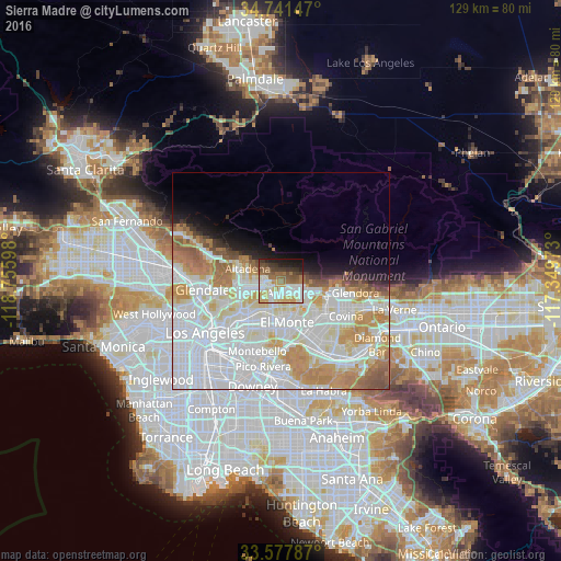
Analysis of Sierra Madre night lights 2016
Square area 10x10 km:
 16.67%
90-99
15.93%80-89
6.59%70-79
9.71%60-69
9.52%50-59
11.36%40-49
7.51%30-39
8.61%20-29
6.78%10-19
7.33%0-9
0%Square area 50x50 km:
22.12%90-99
13.66%80-89
5.03%70-79
7.14%60-69
5.87%50-59
2.9%40-49
1.64%30-39
1.31%20-29
1.88%10-19
4.14%0-9
34.31%Clear (daylight) street map image can be seen on geolist.org.
Map coordinates:
34° 44' 29.3" North, 118° 45' 21.5" West
34° 9' 42" North, 118° 3' 10.3" West
33° 34' 40.3" North, 117° 20' 59" West
Some cities around Sierra Madre sort by population:
• Arcadia
2.9 km =1.8 mi,  146°
146°
• Altadena
7.9 km =4.9 mi,  293°
293°
• Monrovia
5.2 km =3.2 mi,  106°
106°
• Temple City
6.1 km =3.8 mi,  184°
184°
• Duarte
7.4 km =4.6 mi, 109°
• San Marino
6.7 km =4.2 mi,  227°
227°
• East Pasadena
3.3 km =2.1 mi,  216°
216°
• Mayflower Village
6.5 km =4 mi,  142°
142°
5395622 (p: 11,163)
Sources (retrieved 2019-11-25):
» Earth at Night: Flat Maps 2012, 2016