East Pasadena night lights from space
Night Light of East Pasadena (California) from space (United States) Src. Average luminocity for 10x10km area is 84.6996% and for 50x50km: 59.5023%.
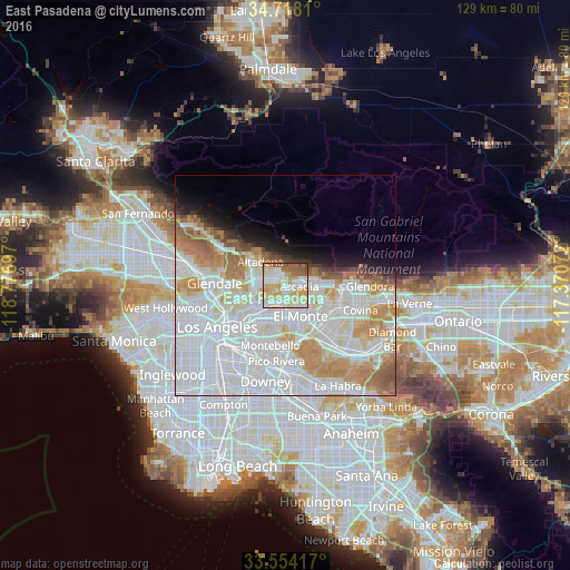
Analysis of East Pasadena night lights 2016
Square area 10x10 km:
 21.06%
90-99
24.36%80-89
23.44%70-79
13.74%60-69
7.33%50-59
8.24%40-49
1.83%30-39
0%20-29
0%10-19
0%0-9
0%Square area 50x50 km:
27.45%90-99
14.83%80-89
5.1%70-79
7.12%60-69
6.08%50-59
3.05%40-49
1.48%30-39
1.29%20-29
1.96%10-19
4.11%0-9
27.53%Clear (daylight) street map image can be seen on geolist.org.
Map coordinates:
34° 43' 5.2" North, 118° 46' 37.1" West
34° 8' 17.3" North, 118° 4' 25.8" West
33° 33' 15" North, 117° 22' 14.6" West
Some cities around East Pasadena sort by population:
• Pasadena
6.6 km =4.1 mi,  279°
279°
• Arcadia
3.5 km =2.2 mi,  87°
87°
• Rosemead
6.4 km =4 mi,  179°
179°
• San Gabriel
5.5 km =3.4 mi,  212°
212°
• Temple City
3.7 km =2.3 mi,  156°
156°
• San Marino
3.5 km =2.2 mi,  238°
238°
• Sierra Madre
3.3 km =2.1 mi,  36°
36°
• Mayflower Village
6.4 km =4 mi,  113°
113°
5345038 (p: 6,144)
Sources (retrieved 2019-11-25):
» Earth at Night: Flat Maps 2012, 2016