Manchester night lights from space
Night Light of Manchester (Iowa) from space (United States) Src. Average luminocity for 10x10km area is 12.0968% and for 50x50km: 1.1435%.
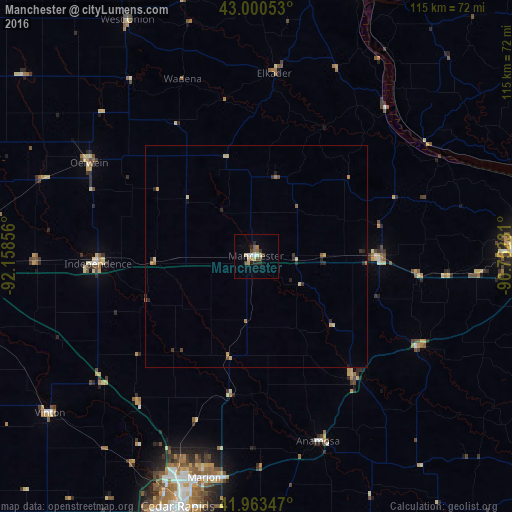
Analysis of Manchester night lights 2016
Square area 10x10 km:
 1.27%
1.27%90-99
1.27%80-89
2.54%70-79
0.63%60-69
1.27%50-59
1.9%40-49
1.9%30-39
1.9%20-29
3.81%10-19
0.16%0-9
83.33%Square area 50x50 km:
0.05%90-99
0.05%80-89
0.31%70-79
0.15%60-69
0.15%50-59
0.19%40-49
0.13%30-39
0.24%20-29
0.46%10-19
0.06%0-9
98.21%Clear (daylight) street map image can be seen on geolist.org.
Map coordinates:
43° 0' 1.9" North, 92° 9' 30.8" West
42° 29' 2.9" North, 91° 27' 19.5" West
41° 57' 48.5" North, 90° 45' 8.3" West
Some cities around Manchester sort by population:
• Cedar Rapids
55.1 km =34.2 mi,  196°
196°
• Marion
51.4 km =31.9 mi,  193°
193°
• Hiawatha
53.2 km =33.1 mi, 200°
• Oelwein
43 km =26.7 mi,  299°
299°
• Independence
35.6 km =22.1 mi,  267°
267°
• Anamosa
44.1 km =27.4 mi,  161°
161°
• Asbury
57.8 km =35.9 mi,  86°
86°
• Vinton
58.4 km =36.3 mi,  233°
233°
4865996 (p: 5,073)
Sources (retrieved 2019-11-25):
» Earth at Night: Flat Maps 2012, 2016