Asbury night lights from space
Night Light of Asbury (Iowa) from space (United States) Src. Average luminocity for 10x10km area is 43.519% and for 50x50km: 5.7148%.
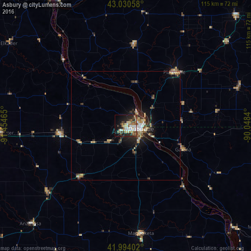
Analysis of Asbury night lights 2016
Square area 10x10 km:
 7.94%
7.94%90-99
6.03%80-89
8.89%70-79
4.29%60-69
6.51%50-59
6.51%40-49
7.3%30-39
4.76%20-29
12.38%10-19
17.14%0-9
18.25%Square area 50x50 km:
0.63%90-99
0.67%80-89
1.04%70-79
0.61%60-69
0.7%50-59
0.82%40-49
1.01%30-39
0.84%20-29
1.94%10-19
3.24%0-9
88.5%Clear (daylight) street map image can be seen on geolist.org.
Map coordinates:
43° 1' 50.1" North, 91° 27' 16.7" West
42° 30' 52" North, 90° 45' 5.5" West
41° 59' 38.5" North, 90° 2' 54.2" West
Some cities around Asbury sort by population:
• Dubuque
7.3 km =4.5 mi,  102°
102°
• Clinton
87.7 km =54.5 mi,  148°
148°
• Platteville
33.1 km =20.6 mi,  42°
42°
• Maquoketa
50 km =31.1 mi,  171°
171°
• Prairie du Chien
67.7 km =42.1 mi,  331°
331°
• Anamosa
63 km =39.1 mi,  224°
224°
• De Witt
78.8 km =49 mi, 167°
• Manchester
57.8 km =35.9 mi,  266°
266°
4847226 (p: 5,291)
Sources (retrieved 2019-11-25):
» Earth at Night: Flat Maps 2012, 2016