Hiawatha night lights from space
Night Light of Hiawatha (Iowa) from space (United States) Src. Average luminocity for 10x10km area is 65.9825% and for 50x50km: 10.8695%.
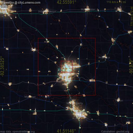
Analysis of Hiawatha night lights 2016
Square area 10x10 km:
 17.62%
90-99
14.13%80-89
3.49%70-79
8.73%60-69
15.71%50-59
13.17%40-49
5.87%30-39
5.87%20-29
9.05%10-19
6.19%0-9
0.16%Square area 50x50 km:
1.97%90-99
1.74%80-89
0.96%70-79
1.47%60-69
1.87%50-59
2.02%40-49
1.17%30-39
1.35%20-29
2.67%10-19
4.91%0-9
79.87%Clear (daylight) street map image can be seen on geolist.org.
Map coordinates:
42° 33' 21.3" North, 92° 23' 6.9" West
42° 2' 9" North, 91° 40' 55.6" West
41° 30' 41.3" North, 90° 58' 44.4" West
Some cities around Hiawatha sort by population:
• Cedar Rapids
4.4 km =2.7 mi,  134°
134°
• Iowa City
43.5 km =27 mi,  163°
163°
• Marion
7 km =4.3 mi,  91°
91°
• Coralville
40.8 km =25.4 mi,  168°
168°
• North Liberty
32.6 km =20.3 mi, 167°
• Independence
51.1 km =31.8 mi,  340°
340°
• Anamosa
33.7 km =20.9 mi,  76°
76°
• Vinton
31.8 km =19.8 mi,  297°
297°
4860452 (p: 7,199)
Sources (retrieved 2019-11-25):
» Earth at Night: Flat Maps 2012, 2016