Lochbuie night lights from space
Night Light of Lochbuie (Colorado) from space (United States) Src. Average luminocity for 10x10km area is 21.9184% and for 50x50km: 23.956%.
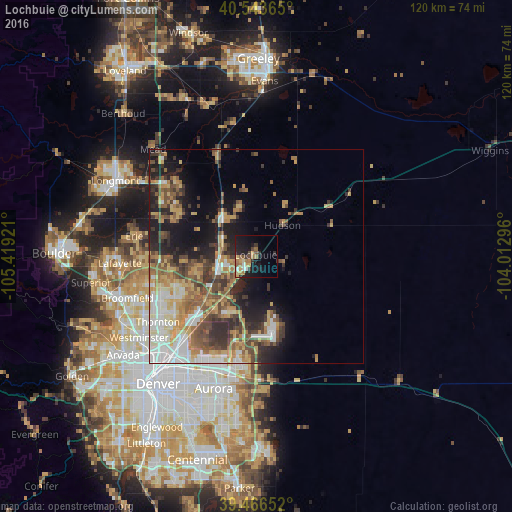
Analysis of Lochbuie night lights 2016
Square area 10x10 km:
 1.53%
1.53%90-99
1.19%80-89
2.89%70-79
3.57%60-69
6.12%50-59
3.06%40-49
2.55%30-39
3.4%20-29
5.44%10-19
22.62%0-9
47.62%Square area 50x50 km:
4.01%90-99
3.45%80-89
2.96%70-79
4.23%60-69
3.56%50-59
4.32%40-49
3.77%30-39
4.35%20-29
4.66%10-19
9.26%0-9
55.44%Clear (daylight) street map image can be seen on geolist.org.
Map coordinates:
40° 32' 37.1" North, 105° 25' 9.2" West
40° 0' 26" North, 104° 42' 57.9" West
39° 27' 59.5" North, 104° 0' 46.7" West
Some cities around Lochbuie sort by population:
• Thornton
26.7 km =16.6 mi,  234°
234°
• Northglenn
26.8 km =16.7 mi,  239°
239°
• Brighton
9.2 km =5.7 mi,  254°
254°
• Welby
28.1 km =17.5 mi, 227°
• Firestone
22.1 km =13.7 mi,  301°
301°
• Frederick
21.4 km =13.3 mi, 298°
• Fort Lupton
11.9 km =7.4 mi,  316°
316°
• Derby
25.4 km =15.8 mi,  222°
222°
5579170 (p: 5,390)
Sources (retrieved 2019-11-25):
» Earth at Night: Flat Maps 2012, 2016