Firestone night lights from space
Night Light of Firestone (Colorado) from space (United States) Src. Average luminocity for 10x10km area is 38.8263% and for 50x50km: 27.2142%.
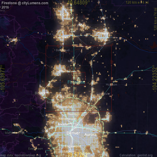
Analysis of Firestone night lights 2016
Square area 10x10 km:
 1.3%
1.3%90-99
0.97%80-89
6.33%70-79
9.09%60-69
5.68%50-59
15.26%40-49
7.47%30-39
8.93%20-29
8.6%10-19
21.92%0-9
14.45%Square area 50x50 km:
2.32%90-99
2.8%80-89
4%70-79
5.39%60-69
5.11%50-59
5.14%40-49
4.04%30-39
4.66%20-29
7.21%10-19
16.71%0-9
42.61%Clear (daylight) street map image can be seen on geolist.org.
Map coordinates:
40° 38' 53.1" North, 105° 38' 23.2" West
40° 6' 44.9" North, 104° 56' 11.9" West
39° 34' 21.4" North, 104° 14' 0.7" West
Some cities around Firestone sort by population:
• Longmont
15.3 km =9.5 mi,  293°
293°
• Brighton
17.3 km =10.7 mi,  145°
145°
• Lafayette
18.6 km =11.6 mi,  224°
224°
• Erie
11.9 km =7.4 mi,  234°
234°
• Frederick
1.5 km =0.9 mi,  181°
181°
• Gunbarrel
20.7 km =12.9 mi,  254°
254°
• Fort Lupton
11 km =6.8 mi,  106°
106°
• Lochbuie
22.1 km =13.7 mi,  121°
121°
5577008 (p: 11,999)
Sources (retrieved 2019-11-25):
» Earth at Night: Flat Maps 2012, 2016