Fort Lupton night lights from space
Night Light of Fort Lupton (Colorado) from space (United States) Src. Average luminocity for 10x10km area is 24.8182% and for 50x50km: 24.1079%.
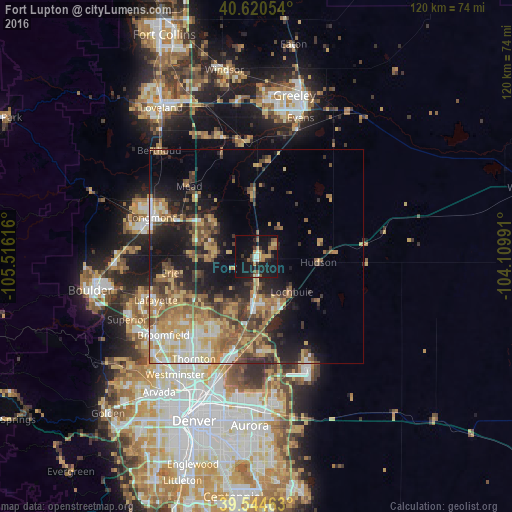
Analysis of Fort Lupton night lights 2016
Square area 10x10 km:
 0.97%
0.97%90-99
2.76%80-89
2.27%70-79
4.71%60-69
3.57%50-59
4.38%40-49
1.62%30-39
5.19%20-29
3.57%10-19
44.48%0-9
26.46%Square area 50x50 km:
2.48%90-99
2.9%80-89
3.81%70-79
4.84%60-69
4.16%50-59
4.54%40-49
3.43%30-39
4.07%20-29
5.03%10-19
12.23%0-9
52.52%Clear (daylight) street map image can be seen on geolist.org.
Map coordinates:
40° 37' 13.9" North, 105° 30' 58.2" West
40° 5' 5" North, 104° 48' 46.9" West
39° 32' 40.7" North, 104° 6' 35.7" West
Some cities around Fort Lupton sort by population:
• Longmont
26.2 km =16.3 mi,  290°
290°
• Northglenn
26.7 km =16.6 mi,  213°
213°
• Brighton
11.1 km =6.9 mi,  183°
183°
• Lafayette
25.6 km =15.9 mi,  246°
246°
• Erie
20.5 km =12.7 mi,  259°
259°
• Firestone
11 km =6.8 mi, 286°
• Frederick
10.7 km =6.6 mi,  278°
278°
• Lochbuie
11.9 km =7.4 mi,  136°
136°
5577153 (p: 7,822)
Sources (retrieved 2019-11-25):
» Earth at Night: Flat Maps 2012, 2016