Northglenn night lights from space
Night Light of Northglenn (Colorado) from space (United States) Src. Average luminocity for 10x10km area is 91.9813% and for 50x50km: 57.9233%.
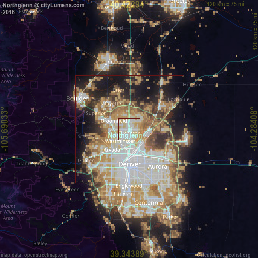

Analysis of Northglenn night lights 2016
Square area 10x10 km:
 26.19%
90-99
35.37%80-89
27.04%70-79
11.39%60-69
0%50-59
0%40-49
0%30-39
0%20-29
0%10-19
0%0-9
0%Square area 50x50 km:
15.5%90-99
12.08%80-89
7.9%70-79
9.31%60-69
7.25%50-59
6.75%40-49
6.02%30-39
5.51%20-29
7.81%10-19
13.34%0-9
8.54%Clear (daylight) street map image can be seen on geolist.org.
Map coordinates:
40° 25' 22.6" North, 105° 41' 25.2" West
39° 53' 7.9" North, 104° 59' 13.9" West
39° 20' 38" North, 104° 17' 2.7" West
Some cities around Northglenn sort by population:
• Thornton
2.3 km =1.4 mi,  146°
146°
• Westminster
6.9 km =4.3 mi,  218°
218°
• Sherrelwood
5.4 km =3.4 mi,  192°
192°
• Welby
5.9 km =3.7 mi,  156°
156°
• Federal Heights
3.9 km =2.4 mi, 194°
• Derby
7.8 km =4.8 mi,  131°
131°
• Twin Lakes
6.9 km =4.3 mi, 192°
• Shaw Heights
6 km =3.7 mi,  232°
232°
5433124 (p: 39,197)
Sources (retrieved 2019-11-25):
» Earth at Night: Flat Maps 2012, 2016