Frederick night lights from space
Night Light of Frederick (Colorado) from space (United States) Src. Average luminocity for 10x10km area is 33.8588% and for 50x50km: 28.835%.
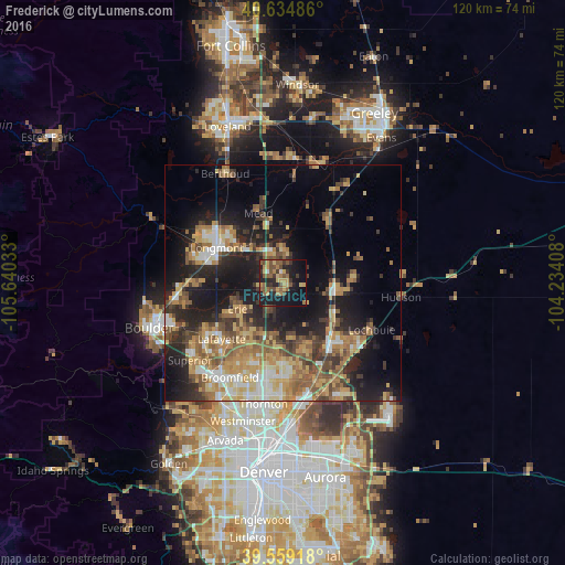
Analysis of Frederick night lights 2016
Square area 10x10 km:
 0.81%
0.81%90-99
0.49%80-89
4.55%70-79
7.31%60-69
5.03%50-59
13.64%40-49
6.01%30-39
7.14%20-29
8.12%10-19
31.98%0-9
14.94%Square area 50x50 km:
2.79%90-99
3.28%80-89
4.38%70-79
5.63%60-69
5.24%50-59
5.33%40-49
4.16%30-39
4.67%20-29
7.49%10-19
16.4%0-9
40.64%Clear (daylight) street map image can be seen on geolist.org.
Map coordinates:
40° 38' 5.5" North, 105° 38' 25.2" West
40° 5' 56.9" North, 104° 56' 13.9" West
39° 33' 33" North, 104° 14' 2.7" West
Some cities around Frederick sort by population:
• Longmont
15.9 km =9.9 mi,  298°
298°
• Brighton
16.1 km =10 mi,  141°
141°
• Lafayette
17.5 km =10.9 mi,  227°
227°
• Erie
11 km =6.8 mi,  240°
240°
• Firestone
1.5 km =0.9 mi,  1°
1°
• Gunbarrel
20.3 km =12.6 mi,  258°
258°
• Fort Lupton
10.7 km =6.6 mi,  98°
98°
• Lochbuie
21.4 km =13.3 mi,  118°
118°
5577217 (p: 11,413)
Sources (retrieved 2019-11-25):
» Earth at Night: Flat Maps 2012, 2016