Laurel night lights from space
Night Light of Laurel (Montana) from space (United States) Src. Average luminocity for 10x10km area is 14.1273% and for 50x50km: 6.2182%.
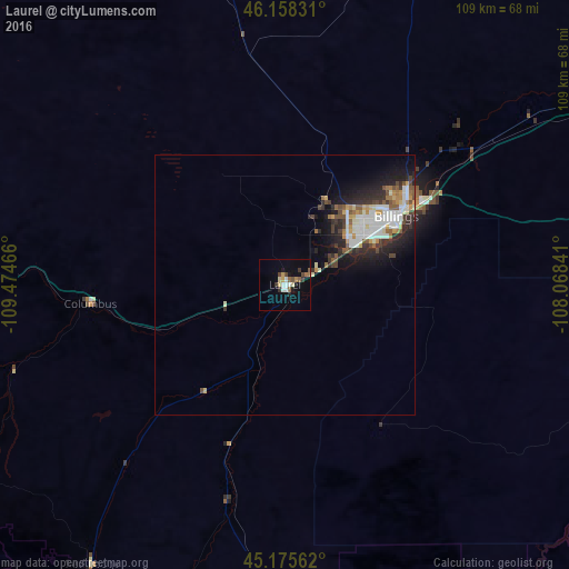
Analysis of Laurel night lights 2016
Square area 10x10 km:
 1.82%
1.82%90-99
1.97%80-89
1.52%70-79
1.52%60-69
1.36%50-59
2.27%40-49
2.27%30-39
1.97%20-29
1.21%10-19
4.7%0-9
79.39%Square area 50x50 km:
1.23%90-99
1.33%80-89
0.5%70-79
0.61%60-69
0.61%50-59
0.73%40-49
0.78%30-39
0.91%20-29
2.03%10-19
3.22%0-9
88.04%Clear (daylight) street map image can be seen on geolist.org.
Map coordinates:
46° 9' 29.9" North, 109° 28' 28.8" West
45° 40' 8.8" North, 108° 46' 17.5" West
45° 10' 32.2" North, 108° 4' 6.3" West
Some cities around Laurel sort by population:
• Billings
24.6 km =15.3 mi,  58°
58°
• Bozeman
176.1 km =109.4 mi,  270°
270°
• Sheridan
172.1 km =106.9 mi,  124°
124°
• Cody
129 km =80.2 mi,  189°
189°
• Livingston
139.1 km =86.4 mi, 269°
• Lockwood
32.3 km =20.1 mi, 58°
• Powell
101.8 km =63.3 mi,  179°
179°
• Lewistown
162.9 km =101.2 mi,  341°
341°
5661766 (p: 6,943)
Sources (retrieved 2019-11-25):
» Earth at Night: Flat Maps 2012, 2016