Lockwood night lights from space
Night Light of Lockwood (Montana) from space (United States) Src. Average luminocity for 10x10km area is 28.9702% and for 50x50km: 6.5452%.
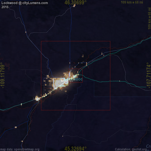
Analysis of Lockwood night lights 2016
Square area 10x10 km:
 4.32%
4.32%90-99
5.36%80-89
2.38%70-79
2.83%60-69
3.13%50-59
6.4%40-49
6.1%30-39
4.32%20-29
7.44%10-19
19.05%0-9
38.69%Square area 50x50 km:
1.23%90-99
1.3%80-89
0.46%70-79
0.6%60-69
0.68%50-59
0.89%40-49
0.89%30-39
1.08%20-29
2.23%10-19
4%0-9
86.64%Clear (daylight) street map image can be seen on geolist.org.
Map coordinates:
46° 18' 25.2" North, 109° 7' 4.8" West
45° 49' 8.8" North, 108° 24' 53.5" West
45° 19' 37" North, 107° 42' 42.3" West
Some cities around Lockwood sort by population:
• Billings
7.8 km =4.8 mi,  239°
239°
• Sheridan
161 km =100 mi,  134°
134°
• Cody
152.3 km =94.6 mi,  199°
199°
• Livingston
167.4 km =104 mi,  264°
264°
• Laurel
32.3 km =20.1 mi, 238°
• Powell
121.4 km =75.4 mi,  192°
192°
• Lewistown
158.6 km =98.5 mi,  330°
330°
• Worland
203.6 km =126.5 mi,  169°
169°
5663135 (p: 6,797)
Sources (retrieved 2019-11-25):
» Earth at Night: Flat Maps 2012, 2016