Bozeman night lights from space
Night Light of Bozeman (Montana) from space (United States) Src. Average luminocity for 10x10km area is 38.3212% and for 50x50km: 3.0969%.
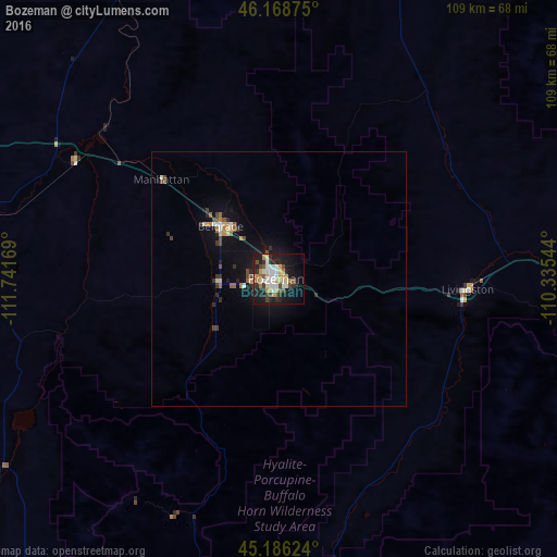

Analysis of Bozeman night lights 2016
Square area 10x10 km:
 7.88%
7.88%90-99
6.52%80-89
5%70-79
5.76%60-69
3.94%50-59
2.27%40-49
6.21%30-39
4.24%20-29
10.91%10-19
28.48%0-9
18.79%Square area 50x50 km:
0.38%90-99
0.38%80-89
0.4%70-79
0.32%60-69
0.37%50-59
0.28%40-49
0.59%30-39
0.44%20-29
0.75%10-19
2.64%0-9
93.46%Clear (daylight) street map image can be seen on geolist.org.
Map coordinates:
46° 10' 7.5" North, 111° 44' 30.1" West
45° 40' 46.7" North, 111° 2' 18.8" West
45° 11' 10.5" North, 110° 20' 7.6" West
Some cities around Bozeman sort by population:
• Butte
121.4 km =75.4 mi,  287°
287°
• Butte-Silver Bow (Balance)
127.9 km =79.5 mi,  281°
281°
• Helena
127.3 km =79.1 mi,  322°
322°
• Anaconda
155.5 km =96.6 mi, 288°
• Helena Valley Southeast
124.3 km =77.2 mi,  326°
326°
• Belgrade
15.2 km =9.4 mi,  314°
314°
• Helena Valley West Central
134.7 km =83.7 mi, 324°
• Livingston
37.2 km =23.1 mi,  92°
92°
5641727 (p: 43,405)
Sources (retrieved 2019-11-25):
» Earth at Night: Flat Maps 2012, 2016