Lansing night lights from space
Night Light of Lansing (Kansas) from space (United States) Src. Average luminocity for 10x10km area is 35.8571% and for 50x50km: 24.0739%.
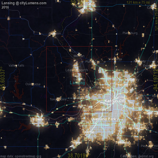
Analysis of Lansing night lights 2016
Square area 10x10 km:
 4.59%
4.59%90-99
5.95%80-89
3.91%70-79
2.72%60-69
4.93%50-59
9.01%40-49
6.63%30-39
3.91%20-29
7.99%10-19
36.9%0-9
13.44%Square area 50x50 km:
4.73%90-99
4.63%80-89
3.3%70-79
3%60-69
3.43%50-59
3.62%40-49
3.53%30-39
3.41%20-29
3.81%10-19
8.77%0-9
57.77%Clear (daylight) street map image can be seen on geolist.org.
Map coordinates:
39° 47' 27.6" North, 95° 36' 12.1" West
39° 14' 55" North, 94° 54' 0.9" West
38° 42' 7.2" North, 94° 11' 49.6" West
Some cities around Lansing sort by population:
• Kansas City
27.9 km =17.3 mi,  122°
122°
• Shawnee
27.8 km =17.3 mi,  145°
145°
• Leavenworth
7.2 km =4.5 mi,  344°
344°
• Gladstone
30.2 km =18.8 mi,  99°
99°
• Bonner Springs
21.1 km =13.1 mi,  176°
176°
• Parkville
19.7 km =12.2 mi,  107°
107°
• Basehor
12.3 km =7.6 mi,  195°
195°
• Tonganoxie
22.4 km =13.9 mi,  226°
226°
4274236 (p: 11,767)
Sources (retrieved 2019-11-25):
» Earth at Night: Flat Maps 2012, 2016