Tonganoxie night lights from space
Night Light of Tonganoxie (Kansas) from space (United States) Src. Average luminocity for 10x10km area is 7.5308% and for 50x50km: 16.5011%.
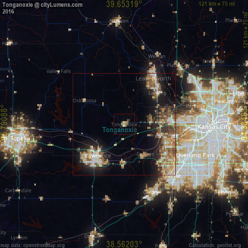
Analysis of Tonganoxie night lights 2016
Square area 10x10 km:
 0%
0%90-99
0.65%80-89
1.3%70-79
0.81%60-69
2.92%50-59
0.16%40-49
2.6%30-39
1.3%20-29
0.32%10-19
0.32%0-9
89.61%Square area 50x50 km:
1.7%90-99
2.25%80-89
2.41%70-79
2.34%60-69
2.92%50-59
3.01%40-49
3.04%30-39
2.84%20-29
3.54%10-19
8.96%0-9
67.01%Clear (daylight) street map image can be seen on geolist.org.
Map coordinates:
39° 39' 11.5" North, 95° 47' 27.2" West
39° 6' 35" North, 95° 5' 15.9" West
38° 33' 43.3" North, 94° 23' 4.7" West
Some cities around Tonganoxie sort by population:
• Lawrence
19.9 km =12.4 mi,  219°
219°
• Shawnee
32.6 km =20.3 mi,  103°
103°
• Leavenworth
26.5 km =16.5 mi,  32°
32°
• Lansing
22.4 km =13.9 mi,  46°
46°
• Bonner Springs
18.5 km =11.5 mi,  107°
107°
• Eudora
18.5 km =11.5 mi,  182°
182°
• De Soto
17.8 km =11.1 mi,  144°
144°
• Basehor
13.3 km =8.3 mi,  74°
74°
4280502 (p: 5,248)
Sources (retrieved 2019-11-25):
» Earth at Night: Flat Maps 2012, 2016