Bonner Springs night lights from space
Night Light of Bonner Springs (Kansas) from space (United States) Src. Average luminocity for 10x10km area is 41.1494% and for 50x50km: 41.1543%.
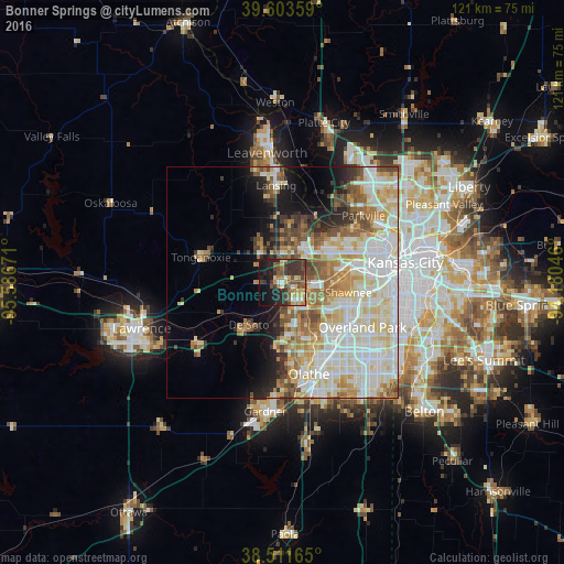
Analysis of Bonner Springs night lights 2016
Square area 10x10 km:
 1.79%
1.79%90-99
3.57%80-89
8.44%70-79
6.17%60-69
5.19%50-59
5.84%40-49
12.99%30-39
16.72%20-29
11.69%10-19
20.29%0-9
7.31%Square area 50x50 km:
10.38%90-99
11.3%80-89
6.71%70-79
4.58%60-69
4.83%50-59
4.3%40-49
3.81%30-39
3.22%20-29
3.54%10-19
6.61%0-9
40.73%Clear (daylight) street map image can be seen on geolist.org.
Map coordinates:
39° 36' 12.9" North, 95° 35' 12.2" West
39° 3' 35" North, 94° 53' 0.9" West
38° 30' 41.9" North, 94° 10' 49.7" West
Some cities around Bonner Springs sort by population:
• Overland Park
20.3 km =12.6 mi,  115°
115°
• Shawnee
14.2 km =8.8 mi,  98°
98°
• Lenexa
17.5 km =10.9 mi,  132°
132°
• Merriam
16.9 km =10.5 mi, 103°
• Mission
20 km =12.4 mi, 100°
• De Soto
11.6 km =7.2 mi,  219°
219°
• Basehor
10.3 km =6.4 mi,  332°
332°
• Tonganoxie
18.5 km =11.5 mi,  287°
287°
4268521 (p: 7,606)
Sources (retrieved 2019-11-25):
» Earth at Night: Flat Maps 2012, 2016