Griffith night lights from space
Night Light of Griffith (Indiana) from space (United States) Src. Average luminocity for 10x10km area is 79.9983% and for 50x50km: 50.2597%.
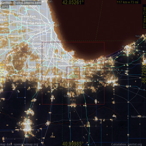
Analysis of Griffith night lights 2016
Square area 10x10 km:
 14.97%
90-99
20.58%80-89
13.95%70-79
16.33%60-69
25%50-59
9.18%40-49
0%30-39
0%20-29
0%10-19
0%0-9
0%Square area 50x50 km:
16.37%90-99
10.79%80-89
5.95%70-79
6.14%60-69
6.56%50-59
5.45%40-49
3.75%30-39
4%20-29
6.2%10-19
9.79%0-9
24.98%Clear (daylight) street map image can be seen on geolist.org.
Map coordinates:
42° 3' 9.4" North, 88° 7' 36.4" West
41° 31' 42.1" North, 87° 25' 25.1" West
40° 59' 59.5" North, 86° 43' 13.9" West
Some cities around Griffith sort by population:
• Hammond
8.8 km =5.5 mi,  313°
313°
• Merrillville
9.1 km =5.7 mi,  123°
123°
• Schererville
6.1 km =3.8 mi,  205°
205°
• Munster
8.4 km =5.2 mi,  298°
298°
• Highland
3.7 km =2.3 mi,  320°
320°
• Dyer
9 km =5.6 mi,  245°
245°
• Saint John
9.5 km =5.9 mi,  203°
203°
• Lynwood
9.6 km =6 mi,  268°
268°
4920986 (p: 16,378)
Sources (retrieved 2019-11-25):
» Earth at Night: Flat Maps 2012, 2016