Jackson Heights night lights from space
Night Light of Jackson Heights (New York) from space (United States) Src. Average luminocity for 10x10km area is 99.3263% and for 50x50km: 80.2663%.
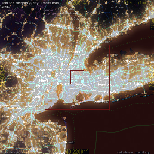

Analysis of Jackson Heights night lights 2016
Square area 10x10 km:
 81.17%
90-99
16.4%80-89
2.11%70-79
0.32%60-69
0%50-59
0%40-49
0%30-39
0%20-29
0%10-19
0%0-9
0%Square area 50x50 km:
45.21%90-99
17.93%80-89
5.44%70-79
6.06%60-69
4.74%50-59
2.76%40-49
2.33%30-39
2.3%20-29
4.36%10-19
5.94%0-9
2.93%Clear (daylight) street map image can be seen on geolist.org.
Map coordinates:
41° 17' 10.1" North, 74° 35' 18.7" West
40° 45' 20.4" North, 73° 53' 7.5" West
40° 13' 15.3" North, 73° 10' 56.2" West
Some cities around Jackson Heights sort by population:
• Astoria
4.2 km =2.6 mi,  295°
295°
• Elmhurst
2.2 km =1.4 mi,  163°
163°
• Corona
2.3 km =1.4 mi,  114°
114°
• Maspeth
4.3 km =2.7 mi,  212°
212°
• Rego Park
4.3 km =2.7 mi,  139°
139°
• Woodside
2 km =1.2 mi,  235°
235°
• Middle Village
4.4 km =2.7 mi,  175°
175°
• East Elmhurst
1.8 km =1.1 mi,  70°
70°
5122477 (p: 67,067)
Sources (retrieved 2019-11-25):
» NASA, Earths city lights 1995
» NASA city lights 2003
» Earth at Night: Flat Maps 2012, 2016