East Elmhurst night lights from space
Night Light of East Elmhurst (New York) from space (United States) Src. Average luminocity for 10x10km area is 98.6477% and for 50x50km: 79.4137%.
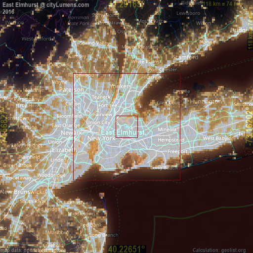
Analysis of East Elmhurst night lights 2016
Square area 10x10 km:
 75.81%
90-99
18.83%80-89
4.22%70-79
0.49%60-69
0.65%50-59
0%40-49
0%30-39
0%20-29
0%10-19
0%0-9
0%Square area 50x50 km:
43.99%90-99
17.42%80-89
5.42%70-79
6.22%60-69
5.2%50-59
3.19%40-49
2.69%30-39
2.41%20-29
4.4%10-19
6.07%0-9
2.99%Clear (daylight) street map image can be seen on geolist.org.
Map coordinates:
41° 17' 29.9" North, 74° 34' 5.8" West
40° 45' 40.4" North, 73° 51' 54.5" West
40° 13' 35.4" North, 73° 9' 43.3" West
Some cities around East Elmhurst sort by population:
• Elmhurst
3 km =1.9 mi,  201°
201°
• Corona
1.6 km =1 mi,  165°
165°
• Forest Hills
5.2 km =3.2 mi, 165°
• Jackson Heights
1.8 km =1.1 mi,  250°
250°
• Rego Park
4 km =2.5 mi,  164°
164°
• Woodside
3.8 km =2.4 mi,  242°
242°
• Kew Gardens Hills
4.9 km =3 mi,  134°
134°
• College Point
3.3 km =2.1 mi,  28°
28°
5115835 (p: 23,150)
Sources (retrieved 2019-11-25):
» Earth at Night: Flat Maps 2012, 2016